Projects
-
Critical Metals, Ontario
-
Precious Metals
-
Diamonds
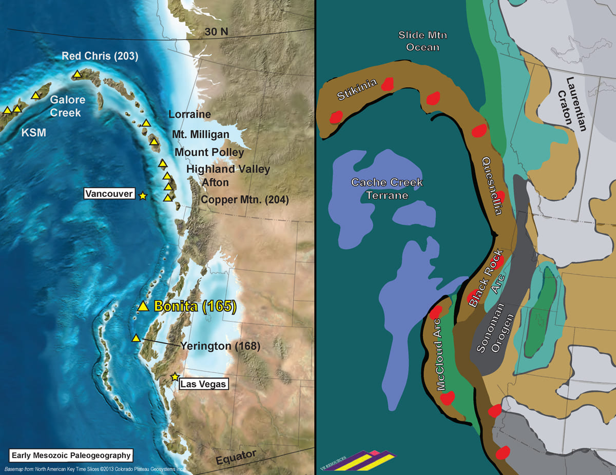
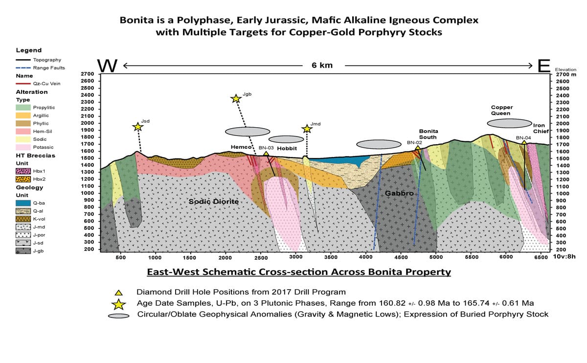
The Bonita property is within a district of historic copper, gold and iron workings in the southern part of the Jackson Range in northwestern Nevada. The showings are unified by a porphyry-style hydrothermal-magmatic system within a polyphase intrusion. The alteration footprint is large, dominated by albite and specularite, within which copper sulfide and gold mineralization which has been mapped and sampled by VR starting in 2014 over an area of approximately 4 x 5 kilometers. Bonita formed in the northern part of the Triassic-Jurassic Black Rock volcanic arc, host to the past-producing Yerington copper camp located southeast of Reno.
VR has identified several large and specific exploration targets for porphyry copper-gold mineralization at Bonita during its early-stage surface exploration. The targets are based on the integration of geological mapping, mineral alteration vectors, rock and soil geochemical anomalies, and gravity, magnetic and resistivity geophysical anomalies. Integrated exploration targets represent the potential to discover a buried, porphyry copper-gold stock and/or breccia body which give rise to the various historic workings on surface of copper-gold veins, vein breccia and specularite-cemented syenite breccia.
VR completed an independent NI 43-101 compliant Technical Report in January, 2017. VR’s goal is to complete the first-pass diamond drilling recommended in the report in order to pursue the discovery of a new porphyry copper stock.
First pass drilling was initiated on the Copper Queen and Hemco targets in 2017, and followed-up in 2018. VR intends to complete the first-pass drill evaluation of both targets, preceded by the infilling of existing IP geophysical lines to improve targeting, starting at Copper Queen on the eastern side of the system.
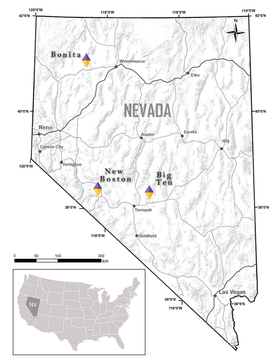
The Bonita property is located in Humboldt County in northwestern Nevada, USA, approximately 150 kilometers northeast of Reno. It is on the southwestern flanks of the Jackson Range, and immediately east of the Black Rock desert.
The property is accessible by paved and gravel county roads from the town of Winnemucca located 75 kilometers to the southeast. The property itself is accessed by a network of active roads and historic trails established for both agriculture and artisanal prospecting and mining.
Overall the terrain is hilly at Bonita. Ridges with 200–300 metres of topographic relief flank a central, valley-covered depression. Elevation ranges from less than 1,200 metres on the western flanks of the Red Butte Mountain range on the western flank of the property, to greater than 2,000 metres on the eastern flank of the property, which is on the southwestern flanks of the South Jackson Mountain Range.
Climate is semi-arid to arid, vegetation is sparse and animal life is minimal. Sage brush and grasses cover a desert gravel on gentle valley slopes. There are spaced, stunted juniper trees at higher elevations with winter snowpack.
Outcrop is exposed over most of the property, excepting the northerly trending central valley depression of mixed alluvial cover and Tertiary basalt. There is virtually no soil development at Bonita. Ridge slopes are craggy outcrop and coarse colluvium. Rounded knolls and low relief slopes have a regolith veneer typically less than 10 centimetres thick on top of weathered outcrop.
The Bonita property currently consists of 43 claims in one contiguous block covering an area of approximately of 355 hectares (878 acres). It covers the Copper Queen target for a near-surface porphyry stock on the eastern side of the overall porphyry copper-gold hydrothermal alteration system exposed on surface at Bonita.
It is on land administered by the federal Bureau of Land Management (BLM). There are no state or federal land use designations, or privately owned land, which impede access to the property, nor is the property within the BLM’s broadly defined area of sage grouse protection.
The property is owned 100% by VR, registered to the Company’s wholly-owned, Nevada-registered US subsidiary Renntiger Resources USA Ltd. The property was staked directly by the Company; there are no associated joint venture or carried interests, back-in rights, or royalties.
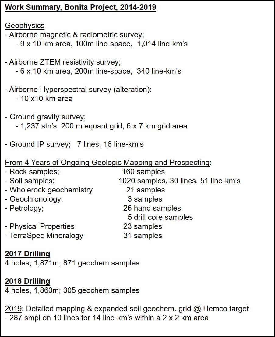
A tabulated compilation of all exploration work completed by VR at Bonita during the past four years, from 2014 to 2019 inclusive, is included in the series of maps and figures which follows this section of text.
Exploration has been more or less continuous at Bonita since late 2014. In chronologic order, work includes:
- Independent NI 43-101 Technical Report completed in February 2017 (www.sedar.com), summarizing ALL data collected by the Company during three years of exploration from 2014 through 2016. The drill programs conducted in the fall of 2017 and summer of 2018 are based on the recommendations in the 43-101 report.
- Geochronology, using uranium-lead systematics on zircon. Concordant age dates ranging from 161 -166 Ma were obtained from three different phases of the Middle Jurassic batholith at Bonita: medium grained, magnetic gabbroic diorite; fine grained sodic diorite, and; aphanitic to quartz-phyric leucocratic monzodiorite (hypabyssal dykes and plugs).
- The ground-based gravity survey completed in 2016 was extended in 2017 and again in 2018 based on positive exploration results. The survey now comprises 1,237 stations over an equant 200 metre station grid covering an area of approximately 6 x 7 kilometres.
- Ground-based Induced Polarization (IP) geophysical survey: 7 test lines across eight exploration targets for 16 line-km’s in total, using both 150 and 200 m dipole spacings.
- Ongoing geological mapping and sampling across the property. A total of 123 rock samples have been collected for geochemistry between 2014 to 2017.
- Ongoing soil sampling across the property: 747
soil
samples were
collected for
geochemistry between 2014 and 2017 from 18 lines covering 37 line-km's;
in 2018, an additional
180 samples were collected from 5 lines covering 9 line-km’s over the
Corral target, and 93
samples from 7 lines covering 4 line-km’s in the Rattlesnake
area.
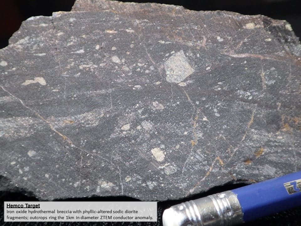
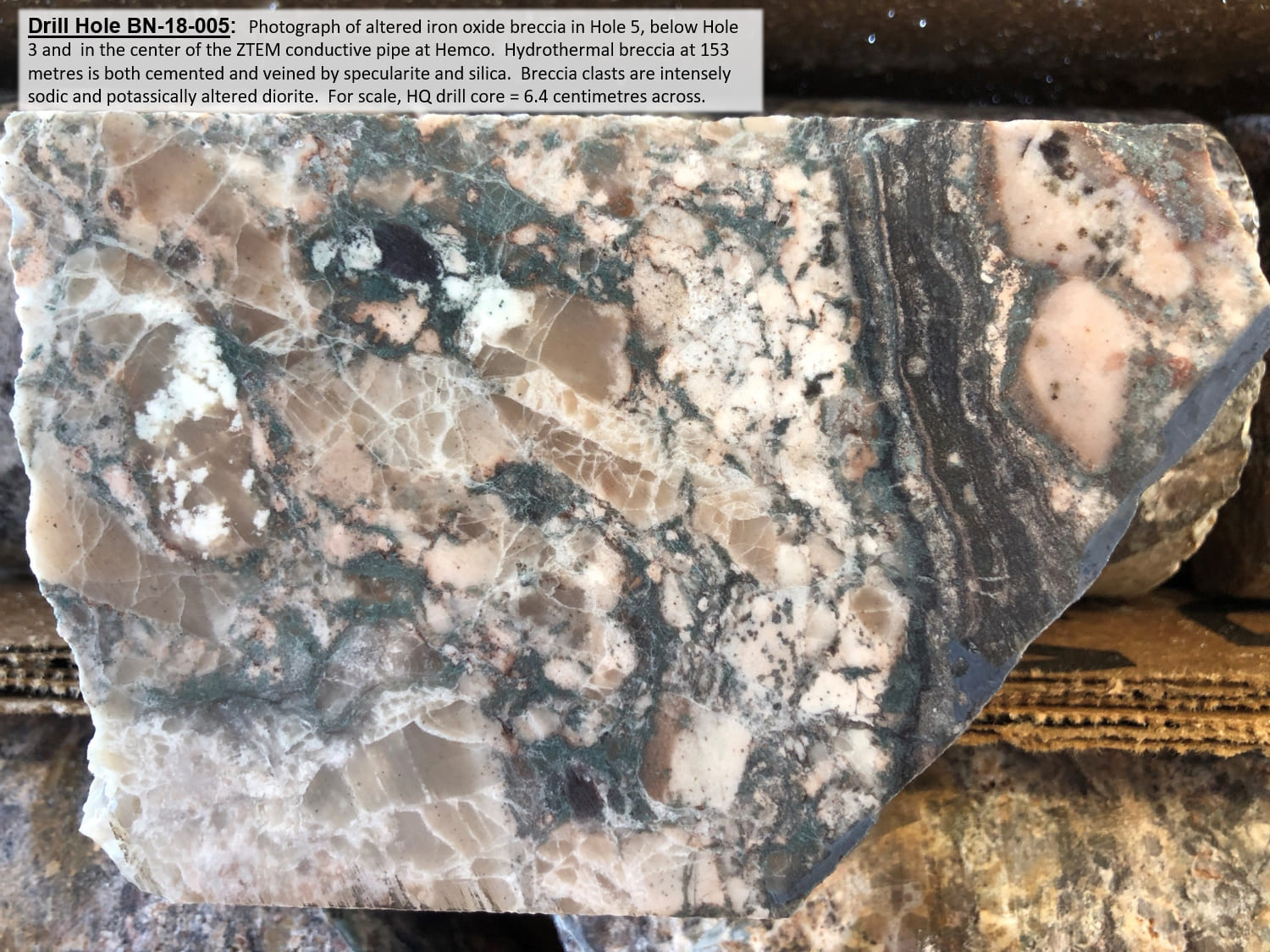
A total of 1,020 soil samples have now been collected at Bonita from 30 lines covering 51 line-kilometres. - Airborne ZTEM electromagnetic survey, summer 2017, to map alteration: 36 lines spaced 200 m apart covering a 6 x 10 km block. Depth-slice plan maps were produced from 2-D inversions, and a block model from 3-D inversions. First pass drilling tests integrated targets associated with both central conductive pipes and peripheral high resistivity alteration rings as defined by ZTEM.
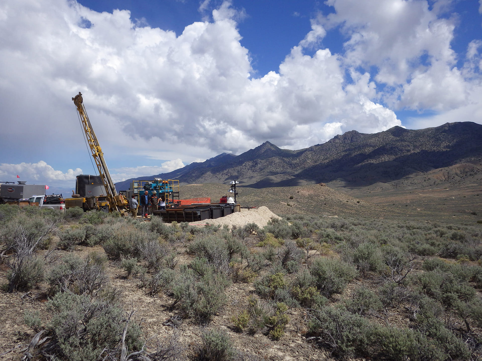
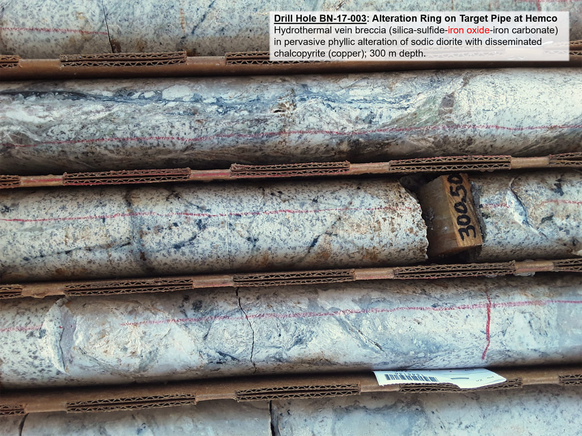
- First pass diamond drill program in the fall of 2017, including four holes on three separate targets for a total of 1,871 metres. A total of 871 samples were taken for geochemistry, normally on successive 1.5 m intervals. Results are summarized in the news release dated January 9, 2017, and available on this website.
- Follow-up diamond drill program in the spring of 2018, including 4 holes at the Hemco target for a total of 1,860 metres, to follow-up on the results from drill hole BN-17-003 completed in 2017. A total of 305 samples were taken for geochemistry, normally on successive 1.5 metre intervals through altered and/or mineralized intervals. Results are summarized in the news release dated August 8, 2018, and available on this website.
- Expanded grid-based geochemistry covering the Hemco target was completed in the summer of 2019, in conjunction with detailed structural mapping, and mapping of mineral alteration facies and veins. Grid-based geochemistry included 287 samples on 10 lines comprising 14 line-km’s within an area approximately 2 x 2 kilometres in size.
Concurrent with the spring 2018 drill program, VR initiated baseline environmental surveys over the Hemco target area for a Plan of Operations (POA) permit application to the BLM. While more drilling is still possible under the current Notice of Intent permit (NOI), this initiative will enable the Company to be ready to complete more detailed delineation drilling in the future.
VR’s overall objective is to complete the Phase I, first-pass diamond drilling recommended in the NI 43-101 report in order to pursue the discovery of a new porphyry copper stock, and evaluate the potential for a cluster of deposits within the overall Bonita porphyry hydrothermal system. First pass drilling was initiated on the Copper Queen and Hemco targets in 2017, and followed-up in 2018. VR intends to complete the first-pass drill evaluation of both targets, preceded by the infilling of existing IP geophysical lines in both areas to refine targeting.
Bonita is an alkaline, polyphase Middle Jurassic batholith that formed at the same time and in the same tectonic belt as the past-producing Yerington porphyry copper camp located some 150 kilometers to the south in west-central Nevada. As shown in the paleotectonic map at the start of the series of maps and follows which follows this text, Yerington and Bonita are the southern end of a continent-scale porphyry copper belt of Early Jurassic age.
Subduction dominated the western margin of North America in early Mesozoic time, including the region now occupied by the Great Basin in the Western United States. A volcanic arc developed in western Nevada, east of the Sierran Arc. Lower Triassic to Lower Jurassic volcano-sedimentary successions were deposited predominantly in shallow marine but also subaerial settings, and co-genetic sub-volcanic plutons are common.
The early Jurassic Yerington batholith and related porphyry copper deposits are located in the central part of the Walker Lane belt, some 75 km southeast of Reno. The batholith is roughly 15 km in diameter. There are numerous copper and gold skarn systems peripheral to the batholith, many of which have been mined. The Pumpkin Hollow skarn system is currently being developed, with a resource estimated at 1.1bt at 0.3-1.5% Cu (Nevada Copper Corporation, 2013). The at-surface Yerington deposit itself was mined by Anaconda Mining Inc. between 1953 and 1965, with an original overall geological resource estimate of approximately 1 billion tons at 0.4% Cu. Exploration is current and ongoing on several deeper satellite deposits discovered while the Yerington mine was in operation, including the Bear deposit (500mt @ 0.4%; Quaterra Resources, 2013), and the Ann Mason deposit (2bt at 0.3% Cu, using 0.2% cut-off; Entrée Gold, 2013).
The Bonita Property is outside of the well-established Carlin-style gold deposit trends in north-central Nevada, but there are several large, past-producing Tertiary epithermal gold deposits located within 50 km of Bonita, including the Hycroft and Sleeper deposits, both associated with Tertiary-aged volcanic rocks which are evident at Bonita.
The active MacFarlane hot spring is located 5 km west of the southern part of the Bonita property. It is delineated by an east-west carbonate ridge some 170 m long, and is co-spatial to a regional-scale structural dislocation that is evident at Bonita.
The Bonita Property is underlain primarily by a diverse Early-Middle Jurassic igneous complex, with lesser volcano-sedimentary cover successions.
The spine of the south Jackson Range itself is dominated by weathering resistant, dark weathering, medium grained, magnetic gabbroic diorite. Fine-grained sodic diorite is more abundant in the Red Butte Mountain area in the western part of the property. Both intrusive phases are intruded by numerous dykes, stocks and plugs of hypabyssal, locally quartz-phyric, leucocratic monzodiorite.
Happy Creek volcanic rocks of inferred Triassic age are mainly undifferentiated andesitic volcanic successions best exposed in the western part of the property, including well-bedded, limestone-bearing sedimentary successions lower in the section. Folded metasedimentary rocks and phyllite are below the Happy Creek volcano-sedimentary successions in the southwest part of the property, and might be Paleozoic in age. The Cretaceous King Lear formation unconformably overlies the Happy Creek andesite volcanic succession in the northwest part of the property, where it consists of locally-derived pebble and boulder conglomerate and interbedded siltstone and greywacke, and lenses of limestone. Tertiary volcanic rocks are mostly layered assemblages of andesite, trachyte and basalt flows, with lesser crystal ash flow tuff and tuffaceous sedimentary rocks exposed in the central and southeastern part of the property, filling the central valley depression.
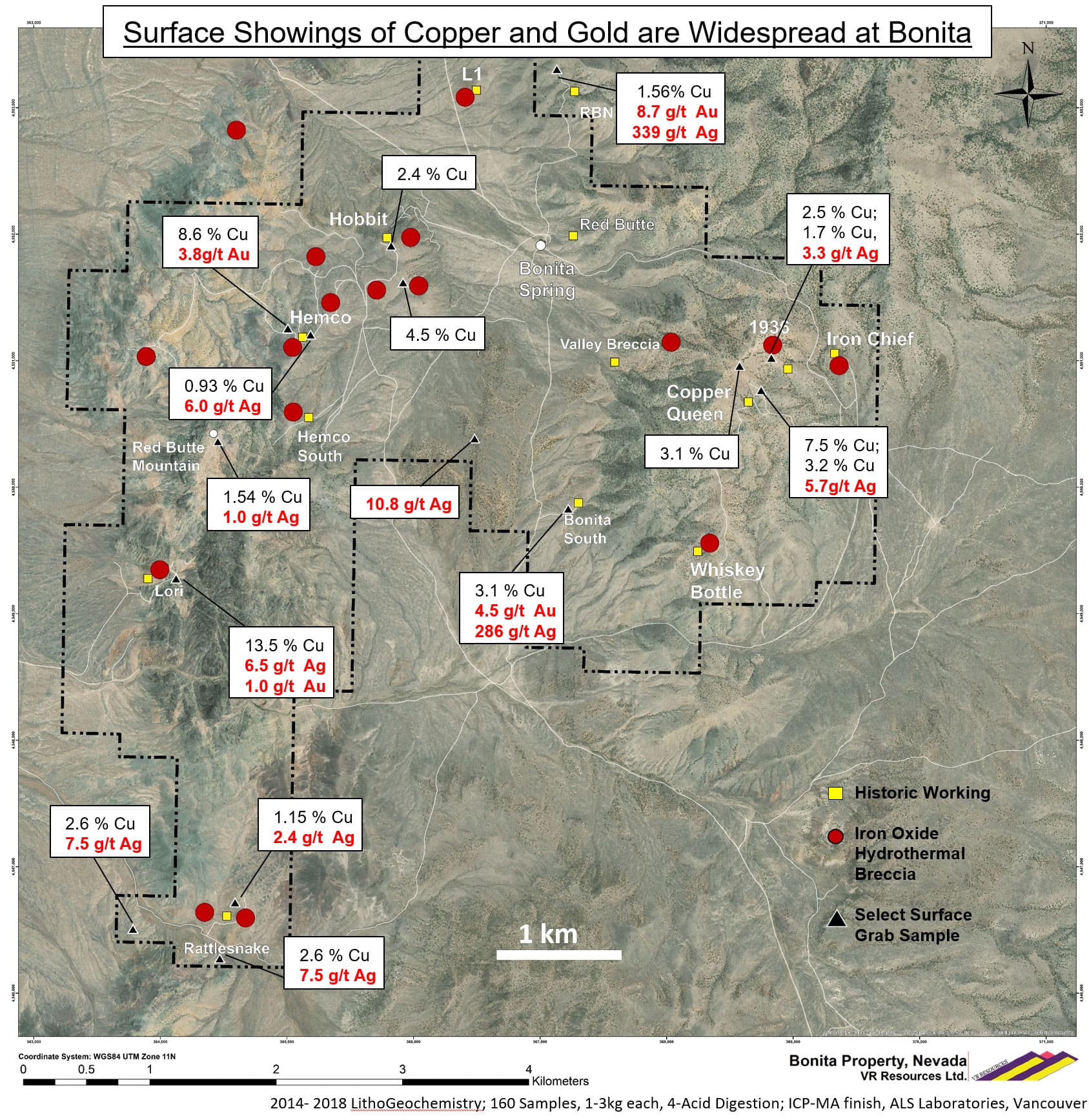
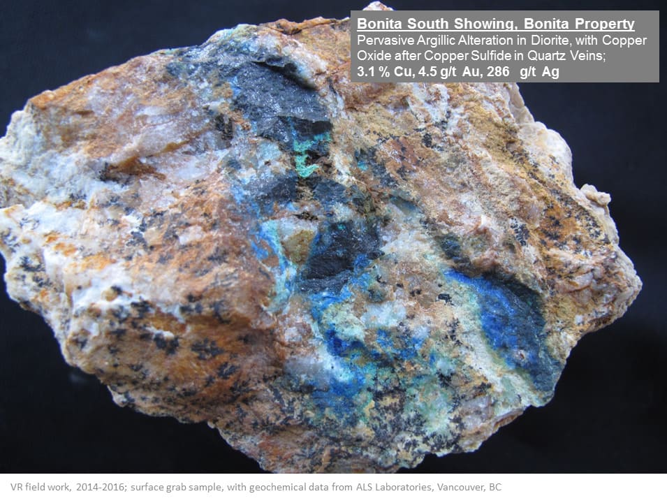
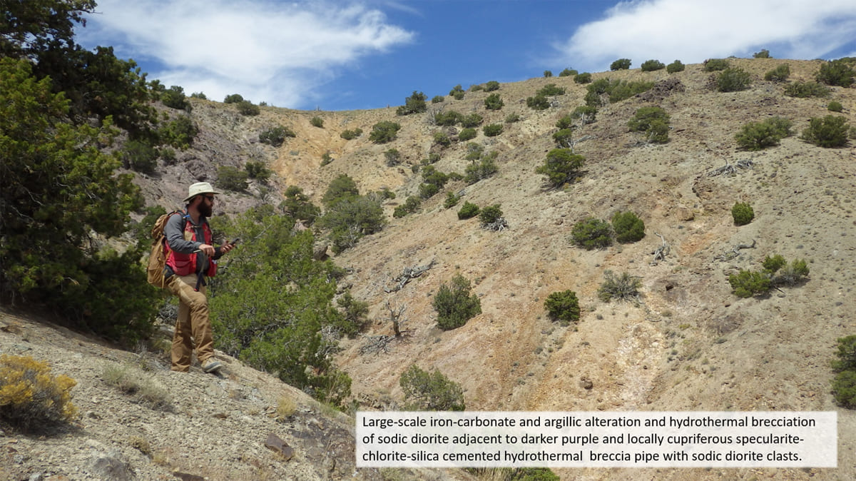
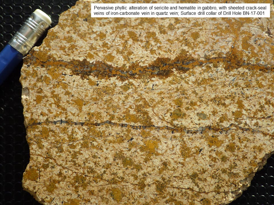
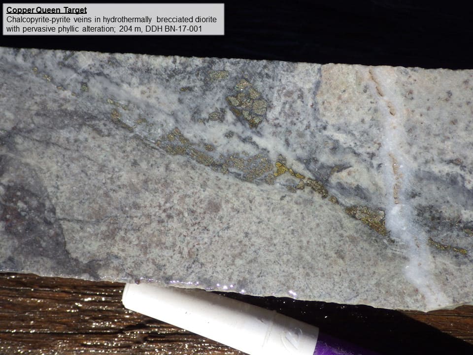
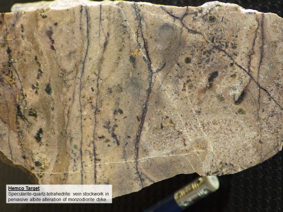
The large alteration footprint at Bonita is clearly delineated by airborne magnetic and hyperspectral surveys, and refined by detailed mapping of alteration zones on the ground, including outer propylitic, argillic, sodic, and phyllic. Recognition of potassic alteration is limited to diorite fragments in iron oxide breccia in the eastern part of the property (Copper Queen – Iron Chief workings), and in quartz veins in drill core in the same area. Copper and gold mineralization at Bonita are generally associated with occurrences of iron oxide breccia, in areas of increased intensity of leucocratic monzodiorite dykes and sheeted quartz veins in sodic diorite. Silica-specularite hydrothermal breccia and iron-carbonate – chlorite hydrothermal breccia is extensive in the Hemco area west of the central valley, and in the Copper Queen – Whiskey Bottle area east of the central valley.
Copper and gold mineralization are generally associated with quartz veins in argillic and phyllic alteration zones in fine grained sodic diorite. Iron oxide breccia commonly has disseminated tetrahedrite in the matrix, and remobilized iron oxide and copper oxide is common in veinlets with quartz, and along fractures. Vertically-oriented hydrothermal vein breccia with quartz-pyrite veins in phyllic-altered sodic diorite is evident in drill core from both the Hemco and Copper Queen targets on the western and eastern sides of the property, respectively.
Overall, the attributes of the Bonita hydrothermal system are most similar to the alkaline porphyry copper-gold deposits located in the belt of Triassic and Jurassic porphyry deposits in western North America as shown on the Early Mesozoic Paleotectonic map on this website below this text.
Because the scattered historic workings for copper, gold and iron on the Bonita Property do not appear in the various regional geology reports and mineral compilation studies published by the USGS and the Nevada Bureau of Mines covering northwestern Nevada, the area has attracted little attention. The South Jackson Range has been “off the radar” of modern exploration because it is outside of the established gold districts in Nevada such as the Walker Lane Belt and the various trends of Carlin-type deposits, and because it is located away from the areas of known porphyry copper deposits at Yerington and Ely.
There are historic surface workings from the early 1900’s scattered across the Bonita property, with underground development including shafts, tunnels, drifts and adits at several locations, including: 1936 Mine; Copper Queen; Bonita South; Red Butte North; Bonita Spring; Hobbit, and; Hemco. Most of the workings target copper oxide on fracture and gold and copper sulfide in quartz veins within sodic- or phyllic-altered sodic diorite or leucocratic monzodiorite dykes.
More recent work, thought to be from the 1940’s - 1960’s era, include surface pits and sort piles for iron at Iron Chief in the eastern part of the property, and an array of pits, trenches and roadcuts within a large goethite colour anomaly covering several square kilometres in the northwestern part of the property.
There is minor drill core from a few, scattered drill collars thought to be completed during the 1980’s at the Bonita South and Red Butte North mines located along the eastern margin of the central valley through the property. The drill holes targeted gold-bearing quartz veins and quartz vein breccia that were the focus of the historic workings, hosted within intensely clay- and albite-altered sodic diorite.