Spring 2026 Drill Program, Jeep Mine
Projects
-
Critical Metals, Ontario
-
Precious Metals
-
Diamonds


New Boston epitomizes the Company’s blue-sky exploration strategy of applying new exploration technologies and modern mineral deposit modeling to large-footprint yet underexplored porphyry copper systems in Nevada. The company will leverage the experience gained from exploration on its Bonita, Junction and Reveille properties in western Nevada to advance the large and fully zoned, porphyry-skarn-breccia system exposed on surface at New Boston.
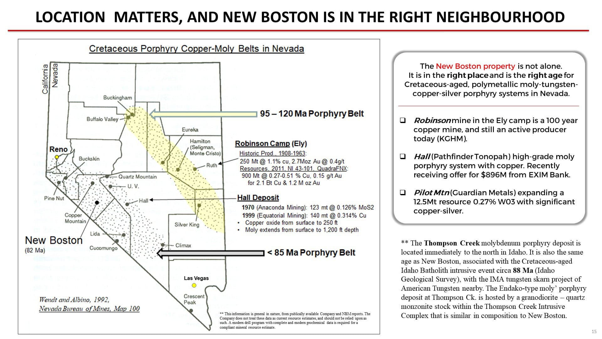
Nevada has both history and pedigree in the world of porphyry copper and moly. New Boston is located in a long and well-established belt of Cretaceous-aged porphyry systems that runs northwest-southeast in west-central Nevada. It is located between the past-producing Yerington porphyry copper camp located approximately 100 km to the northwest, and the Cretaceous Hall moly-copper deposit located approximately 100 kilometres to the southeast. There is current exploration on similar-aged porphyry-skarn moly-tungsten systems at Guardian Metals’ Pilot Mtn project located some 25 km to the southeast of New Boston, and American Tungsten’s IMA project to the northeast in southern Idaho, located in the same Cretaceous porphyry belt which hosts the Thompson Creek moly porphyry deposit.
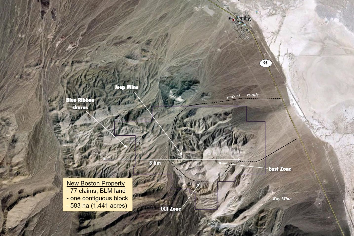
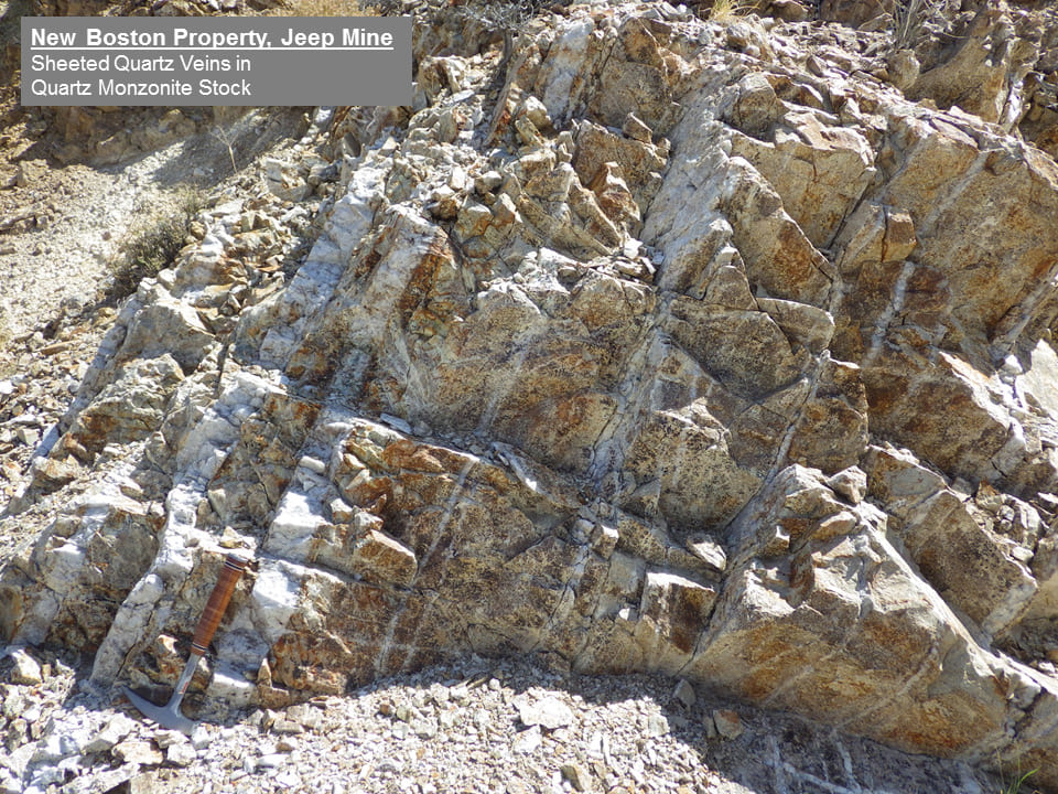
Mineralized sheeted and stockwork veins with tungsten, moly, copper and silver are exposed on surface at New Boston in quartz monzonite stocks and sheeted dacite porphyry dykes, and in country rock limestone of Triassic age, over a strike length of 3 - 4 km east-west. The polymetallic skarn and porphyry mineral system comes to surface within 5 km of the town of Luning on state Highway 95, with active rail and grid power.
Upon completion of two years of surface exploration, VR completed the first leg of its planned first-pass drilling spanning the breadth of sheeted and stockwork veins at New Boston in the spring of 2024, at East Zone. As described below, two holes were completed into the main conductivity anomaly for approximately 1,300 metres, both with stockwork veining throughout. The goal in 2026 is to build on those results by drill testing the co-spatial and rooted, conductivity and IP chargeability anomaly located to the west at Jeep Mine as the potential sulfide center to the overall skarn and porphyry system exposed on surface at New Boston.
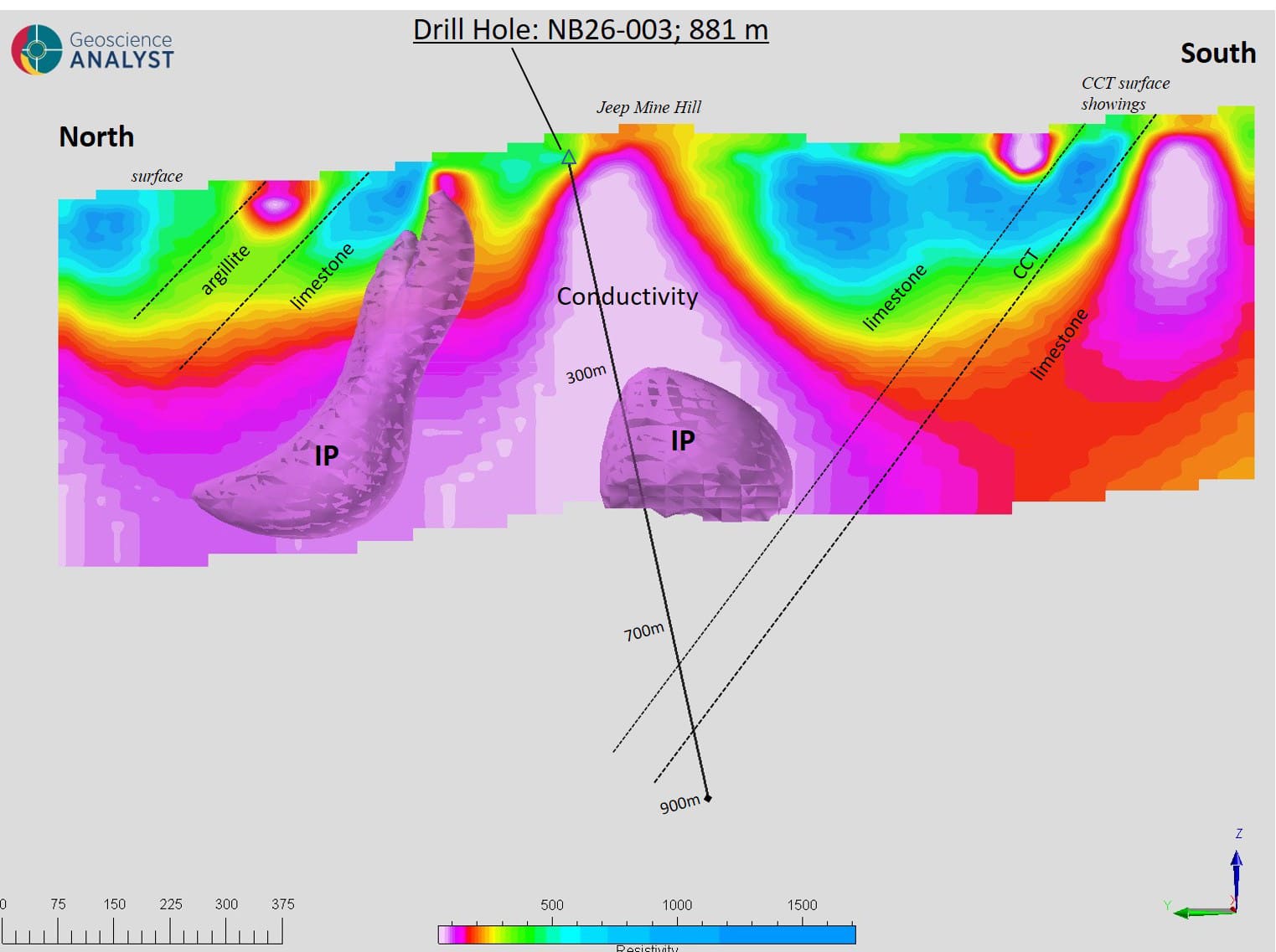
VR initiated that second leg of reconnaissance drilling at Jeep Mine in May, 2026. Drill hole NB26-003 achieved a continuous vein and sulfide intersection across 2,892 ft (881 m) of drill core to confirm the co-spatial, conductivity-chargeability anomaly in the Company’s 2023, 3D-array DCIP geophysical survey as the inferred sulfide center of the large-footprint polymetallic skarn and porphyry system exposed on surface at New Boston.
The current drilling is based upon integrated vectors from three years of detailed surface exploration and airborne surveys by VR, built upon expert historical work in the 1960’s and 70’s. The IP-conductivity anomaly at NB26-003 is previously untested; this is the only known deep drill hole into the southern flank of the Jeep Mine skarn and porphyry center.
The program will benefit from state-of-the-art analytical work at facilities located in nearby Reno, Nevada, because of the logistical efficiencies afforded by the location of New Boston on Highway 95.
New Boston has a mineral system of scale, location for infrastructure, jurisdictional history and pedigree in Nevada, and polymetallic composition all on its side to play into the current push towards domestic critical metal supply and resilience in North America. We look forward to providing further details on this drilling as mineral data and assays are received, results are integrated, and plans are considered for the second half of 2026.
Artisanal mining at the turn of the century focused on high grade copper veins at the Blue Ribbon mine at the west end of the system, and also at Kay Mine in the southeastern periphery of the system.
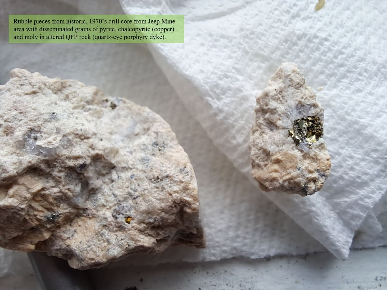
Sheeted and stockwork quartz veins with moly and tungsten at Jeep Mine in the central part of the system was the focus of exploration starting in the late 1960’s and extending to 1981. The mineral division at Conoco especially logged the miles in the field over nearly a decade to both recognize and map the geology, alteration and mineralization across the entire porphyry – skarn system at New Boston. However, that exploration came to an abrupt halt in 1981, as it did across much of North America for that matter, in response to a global collapse in the commodities sector, which in turn seeded the exit of petroleum companies from the minerals and mining sector.
A central porphyry stock was inferred by Conoco for the system of mineralized sheeted veins they mapped on surface, but it was never identified nor drilled prior to the collapse of their exploration. Further, their work predated the advent of modern, multi-element ICP-MS geochemistry in mineral exploration that is instrumental for: 1. determining trace element vectors within the large-footprint alteration footprint on surface using grid-based soil and rock geochemistry spanning the entire skarn and porphyry system, and; 2. Recognizing zonation in copper and moly across the mineral system, and quantifying the polymetallic grade potential of intersections in copper, moly and silver.
Finally, there was a brief period of reconnaissance-style exploration covering the full extent of the porphyry-skarn system at New Boston by a junior gold company in 2010-2011.
VR’s goal is straight forward: to simply finish the expert-level porphyry exploration which began in the 1960’s at New Boston but ended abruptly in 1981, incomplete and never re-visited. The opportunity for VR is twofold:
- To use state-of-the art exploration geophysical technologies that were literally not available in the 1970’s to identify targets for sulfide mineralization in a central porphyry stock which acted as a driver and source for the sheeted veins exposed at surface in host rock limestone along a 3 - 4 km strike, and;
- To use modern, ICP-MS trace element geochemistry to define the grade potential of the polymetallic system for copper, moly and silver.
Relevance and Advantage.
The proximity of New Boston to state HWY 95 provides tremendous logistical advantages for drilling and advanced-stage exploration, as shown in several photos and on several maps provided on this Project Page .
Why now? The US government recently added copper to the top of its Critical Metal list for domestic, raw material supply for sustainable, downstream technologies and industries as the Green Transition emerges (August, 2023). Further, China introduced export bans for tungsten in February, 2025, and for silver on December 31st, highlighting the need for domestic production in North America. The prices of silver and copper, and especially tungsten have responded through Q1 2026. The strategic relevance and potential value of the polymetallic veins of tungsten-moly-copper-silver at New Boston could not be more obvious going forward.
Nevada has both a long history in mining and a well-established pedigree and endowment in copper, and we believe that New Boston has both the size and the polymetallic grade composition with tungsten, moly, copper and silver to contribute to that ongoing legacy.
Conoco developed in 1979 a 3.14 BT geological model to encompass the mineralized sheeted veins exposed on surface over a strike length of 6,900 ft at New Boston, exclusive of a central porphyry stock that was inferred at the time but never identified nor drilled. But technology matters, and some forty years after the historic exploration and reconnaissance drilling by Bear Creek and Conoco came to an end in 1981, new geophysical technologies not available at that time, including both multi-sensor gradient magnetics and 3D array DCIP surveys now provide clear targets for concentrated vein stockworks and potential porphyry stocks with conductive copper sulfide, tungsten and moly in the heart of the large-footprint system at New Boston.
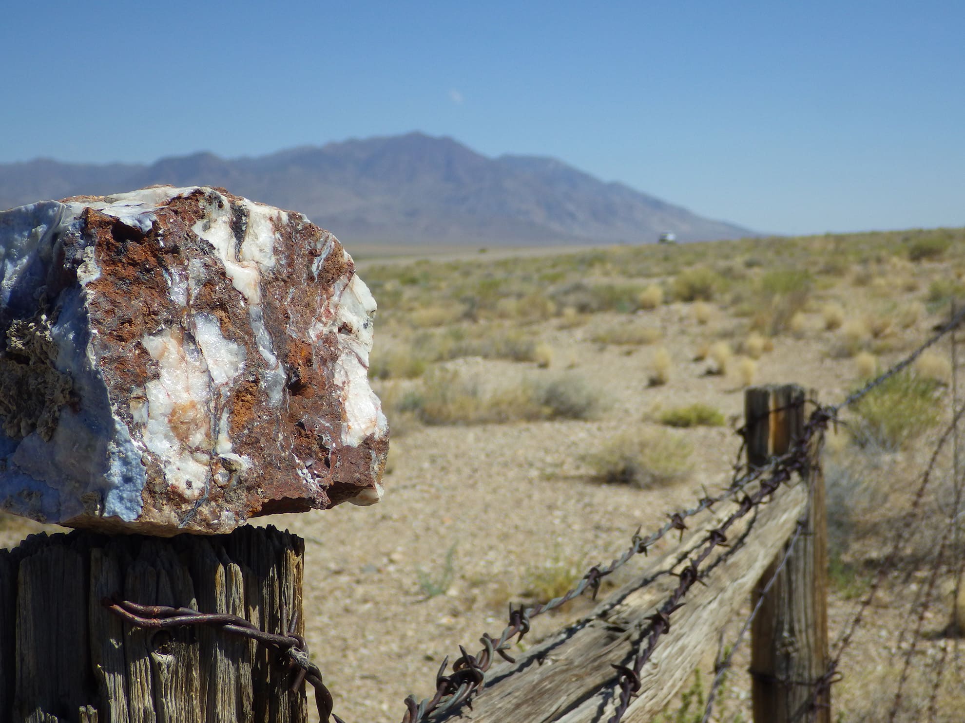
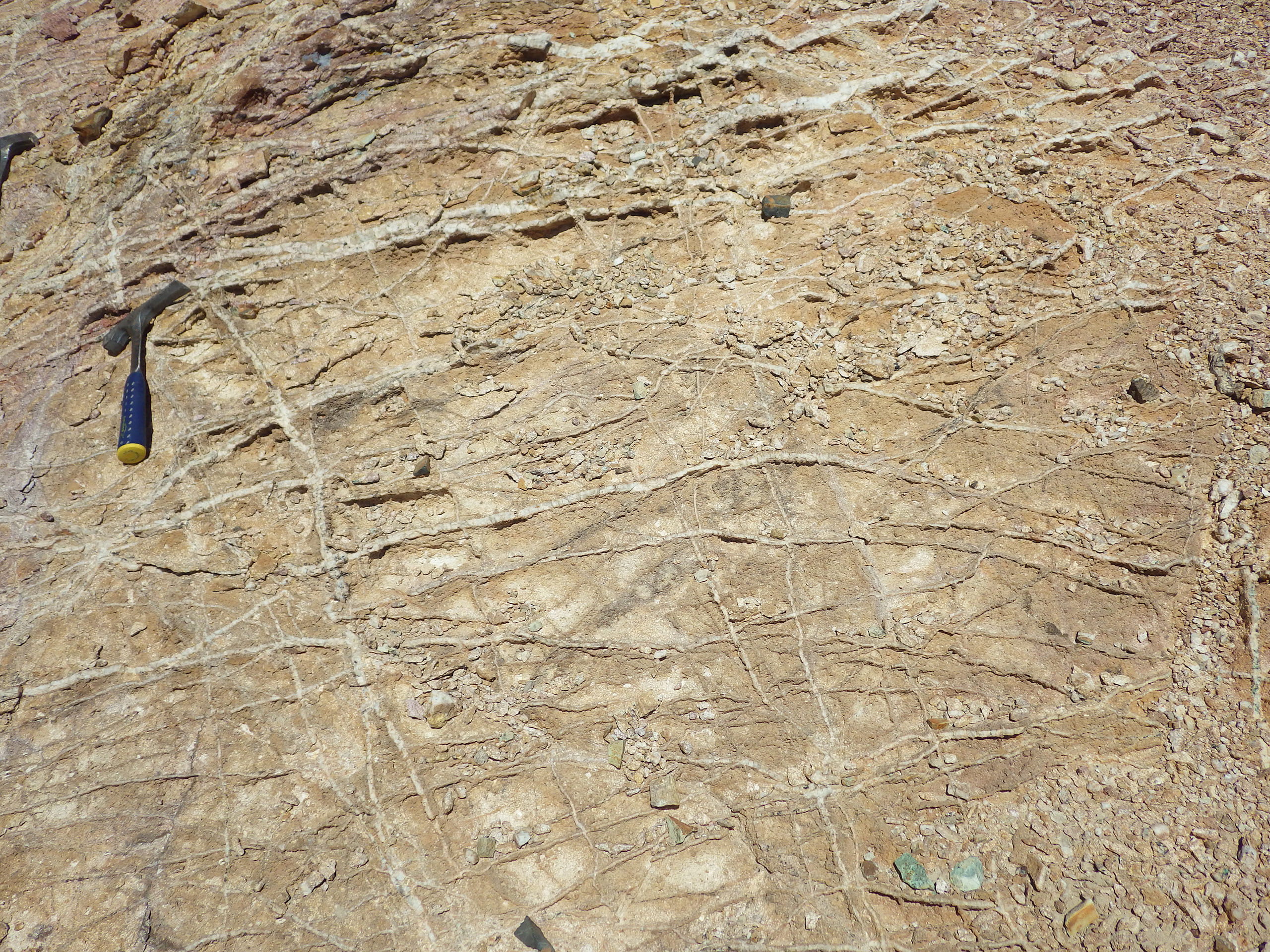
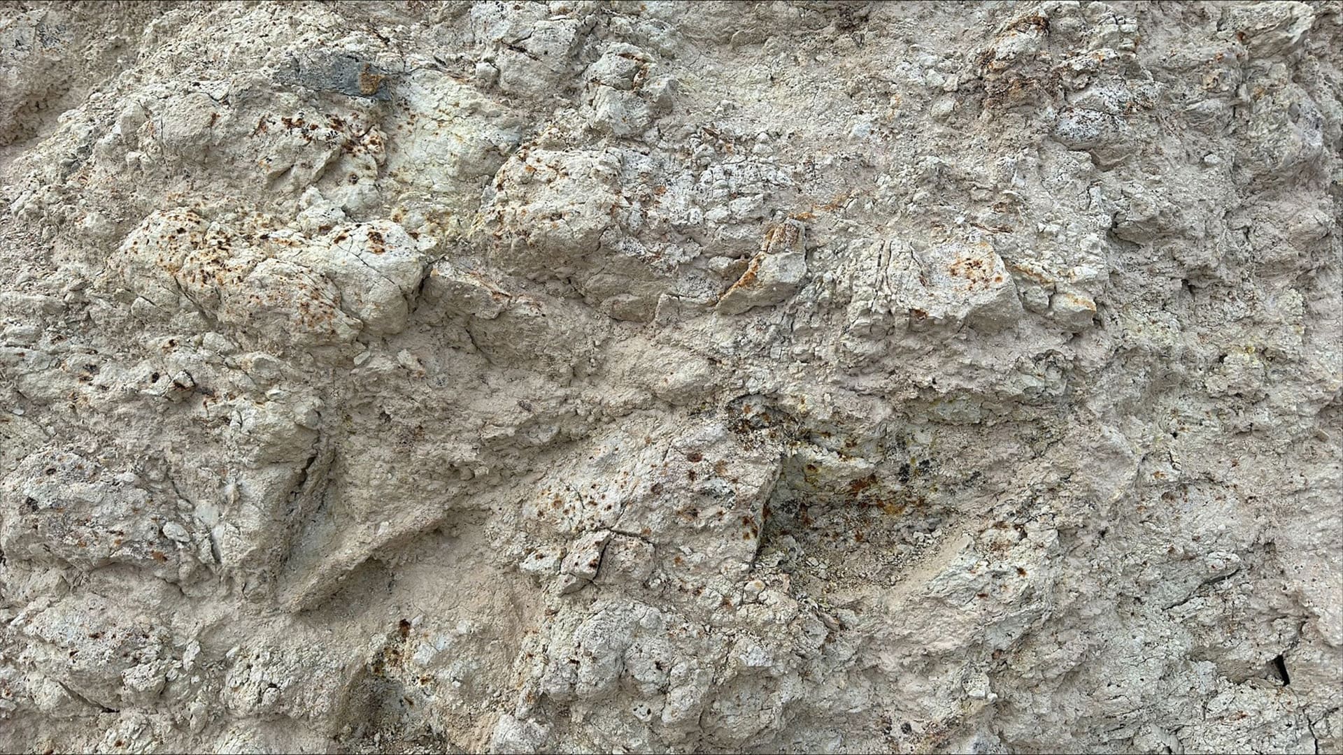
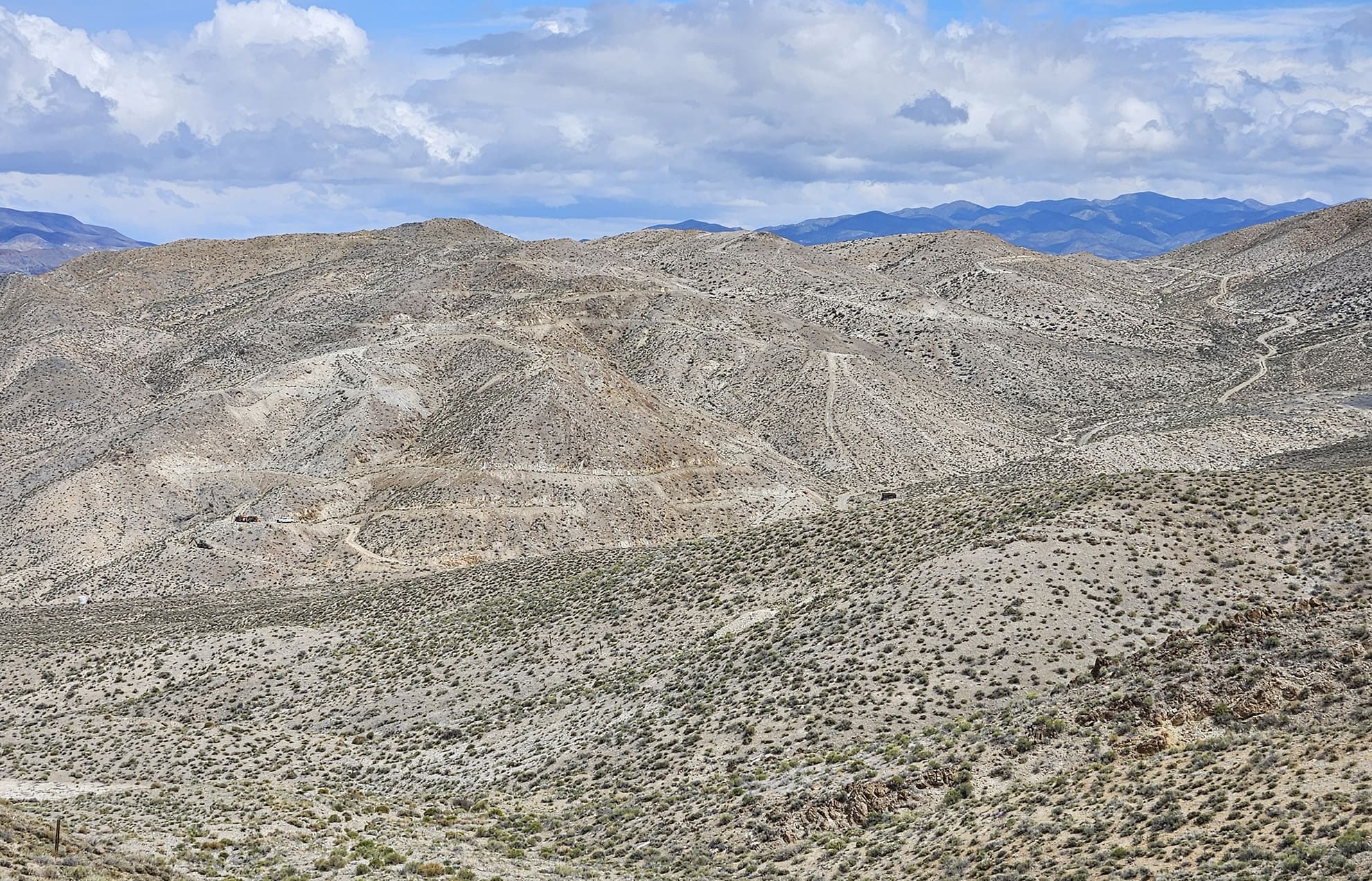
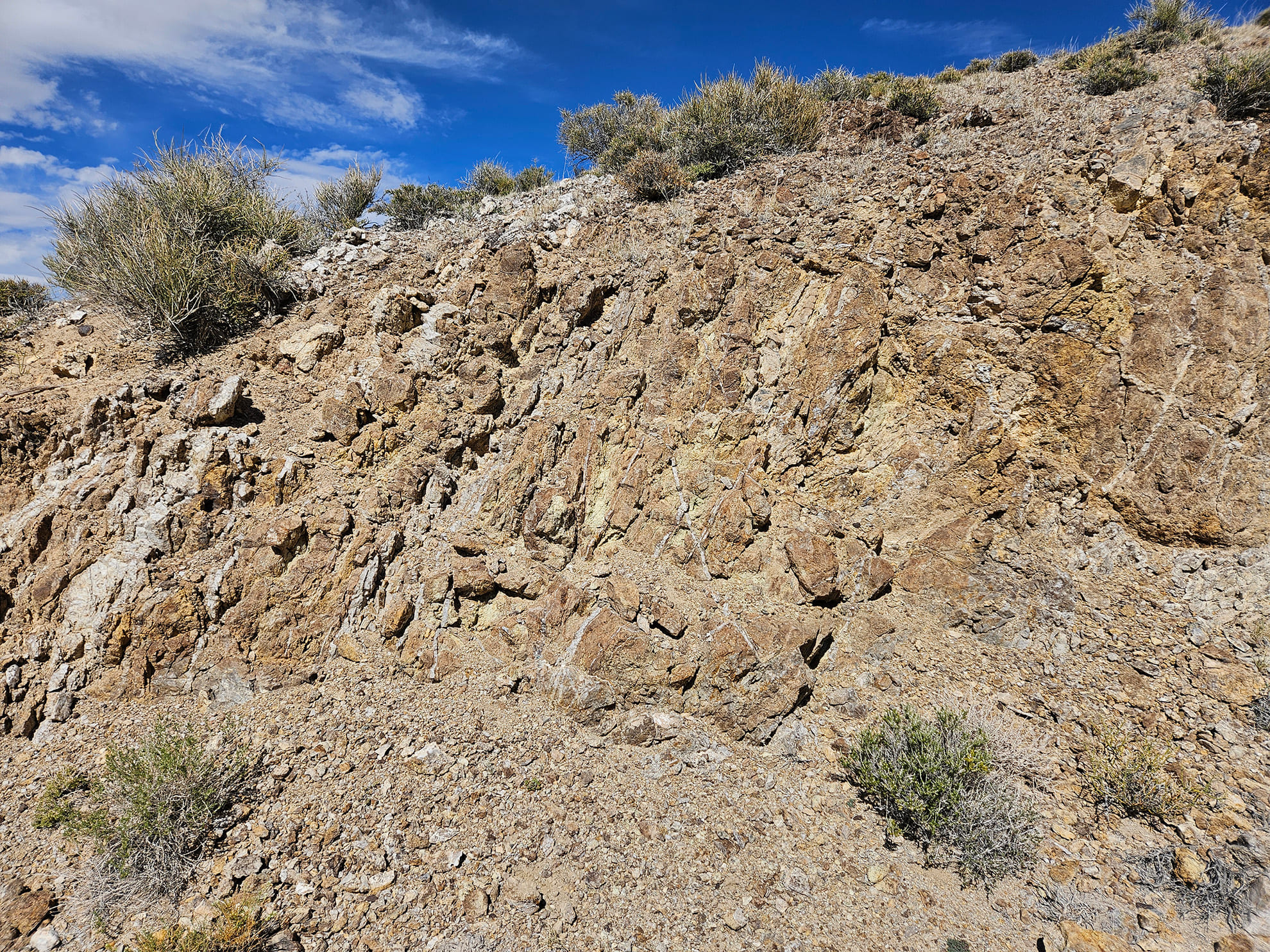
The New Boston porphyry-skarn mineral system comes to surface. Stockwork and sheeted quartz veins in both quartz monzonite plugs and dykes and in country rock Paleozoic limestone are exposed on surface over a strike length of 3 - 4 kilometres ( see field photographs attached to this Project Page ).
VR has the experience in Nevada and expertise in mineral exploration to advance New Boston. Work done to date includes:
- Integration of all regional geoscience data available for the area with all historic exploration data for New Boston obtained with the acquisition of the property;
- Structural mapping of vein and dyke geometries across the entire property, summer 2022, and select vein sampling for geochemical zonation in the summer of 2023.
An airborne magnetic and radiometric survey was completed in April 2023. It was contracted to Precision GeoSurveys Inc. to utilize its exclusive, multi-sensor gradient technology and three-boom design to collect high resolution magnetic data in real time for enhanced subsurface interpretations in three dimensions, in addition to collecting VLF-EM and radiometric data. Survey design on the 3 x 5 km block for high resolution data includes 75 m line-spacing and completion of 8 additional tie lines for 241 line-kms in total, with an average flight altitude maintained at just 35 metres above ground.
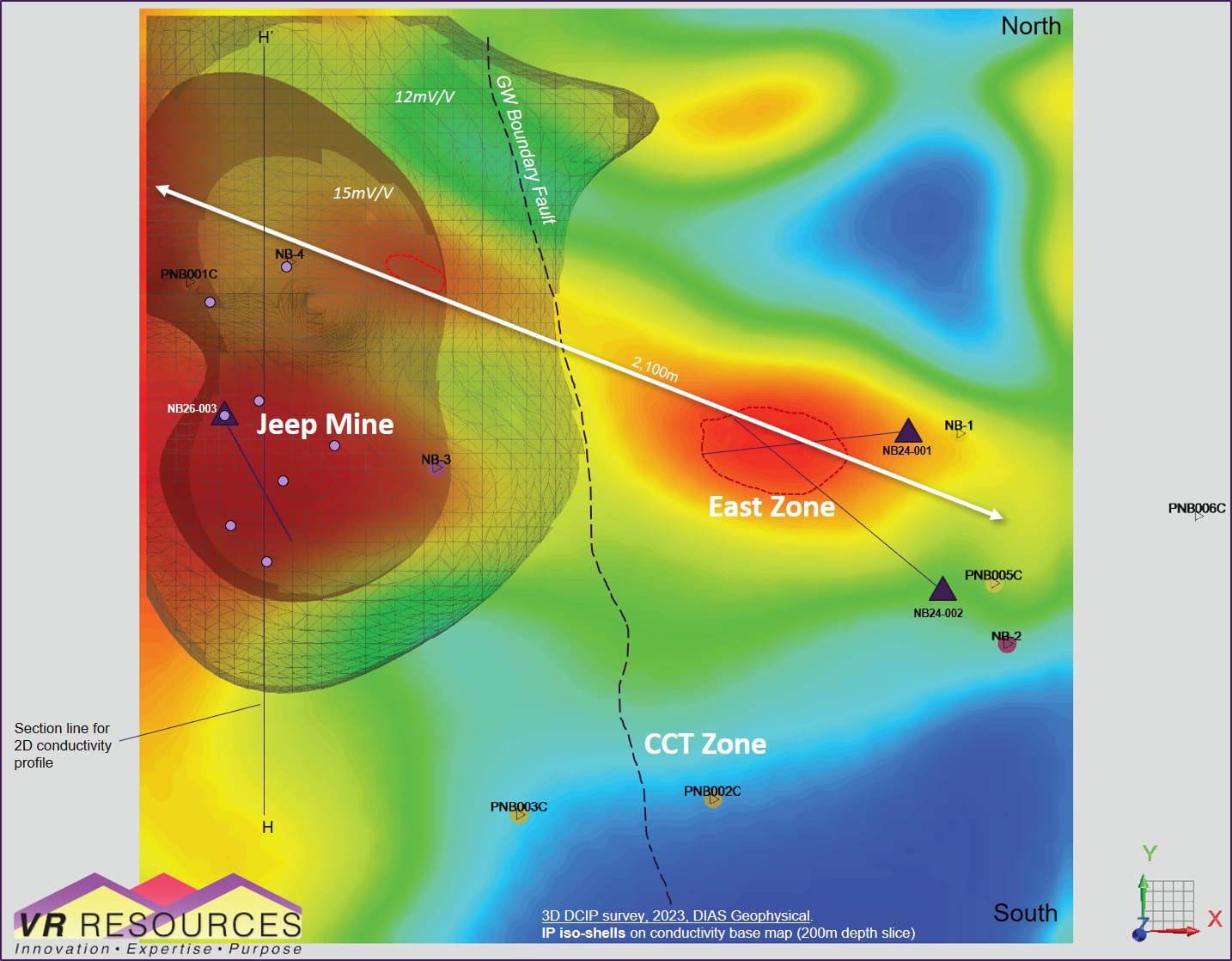
Also in the spring of 2023, VR completed a ground-based 3D IP geophysical survey completed in April by DIAS Geophysical Limited using its proprietary DIAS32 DCIP technology and grid array of transmitter and receiver stations with real time radio frequency data collection. An equant grid of 200 metre–spaced stations over a survey block 1.6 x 2.2 km in size covers the 2,100m strike of sheeted veins exposed on surface between Jeep Mine and East Zone. The survey generated more than 80,000 data points for inversion modeling and resultant 3D models of chargeability and resistivity.
The results of the modern DCIP, magnetic and radiometric surveys were announced on June 26, 2023. Two geophysical plan maps with accompanying cross-sections are provided as stand-alone figures on this Project Page . Highlights include:
-
IP anomaly at Jeep
Mine: 15mV/V, 950 m long, from surface to 500 m depth
and open, which outlines the target for a mineralized porphyry intrusion
below the
Jeep Mine in the central part of the overall skarn and porphyry
system. Note:
- New Boston is a low-pyrite system, so the core IP iso-shell at 15mV within a 12 mV halo is consistent with a base metal sulfide concentration.
- The IP anomaly at depth corresponds to increasing conductivity, below the surface expression of the Jeep Mine hill;
- Drill hole NB-4 with 992 ft @ 0.08% MoS2 is located north of the conductivity core at depth in the center of the large IP anomaly.
-
Conductivity
anomaly at East Zone: high amplitude, 900 m long,
continuous from surface to 500m depth, and open, which outlines the
target for concentrated vein stockworks with conductive sulfide in the
eastern part of the overall skarn and porphyry system.
Note:
- The high amplitude of the conductivity anomaly indicates concentrated and interconnected sulfide minerals;
- Drill hole NB-1 with 318 ft @ 0.14% copper and 0.08% moly is located at the eastern end of the conductivity anomaly;
- The conductivity anomaly correlates with high temperature potassic alteration index in soil geochemistry, and potassium enrichment in porphyry dykes and stocks shown by the airborne radiometric survey, and;
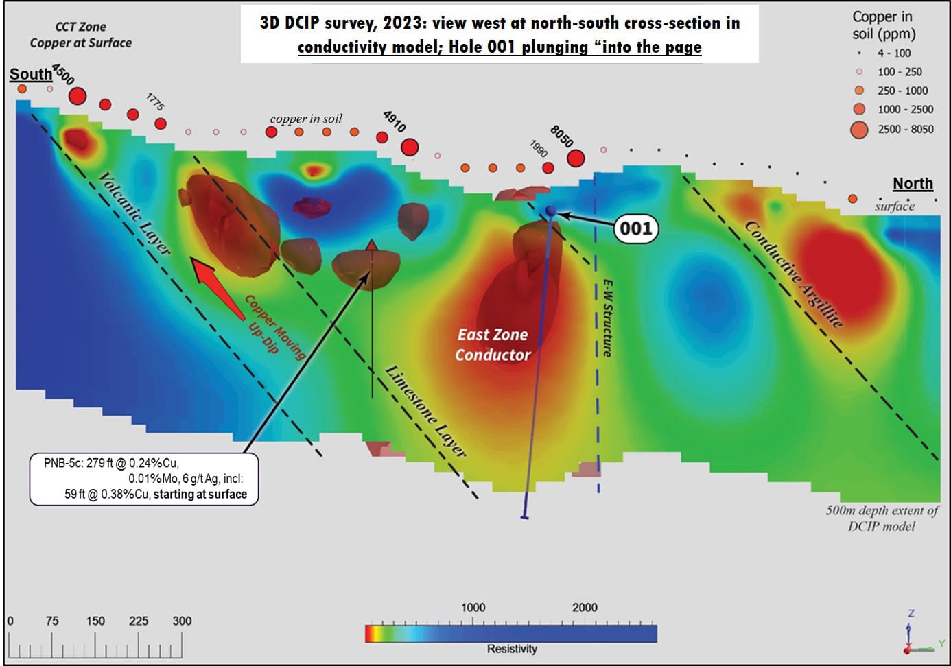
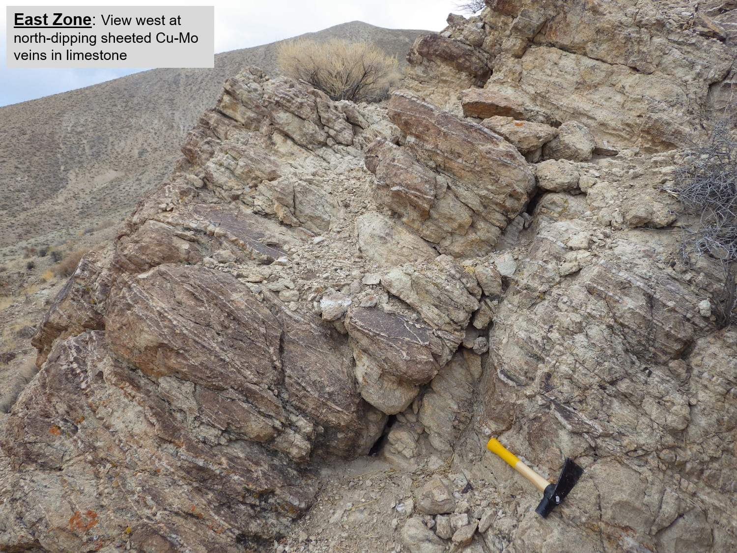
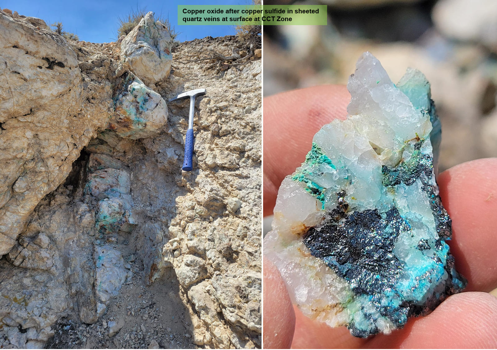
- The conductivity anomaly is inferred to be the source to the copper oxide to the south of East Zone, in quartz veins in north-dipping limestone host rock at the CCT Zone in the southern periphery of the overall system.
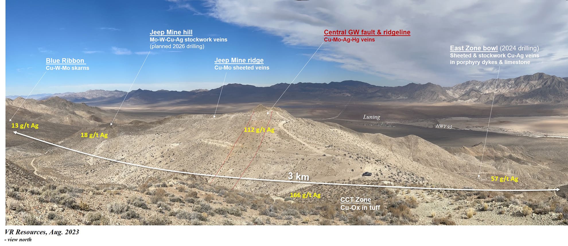
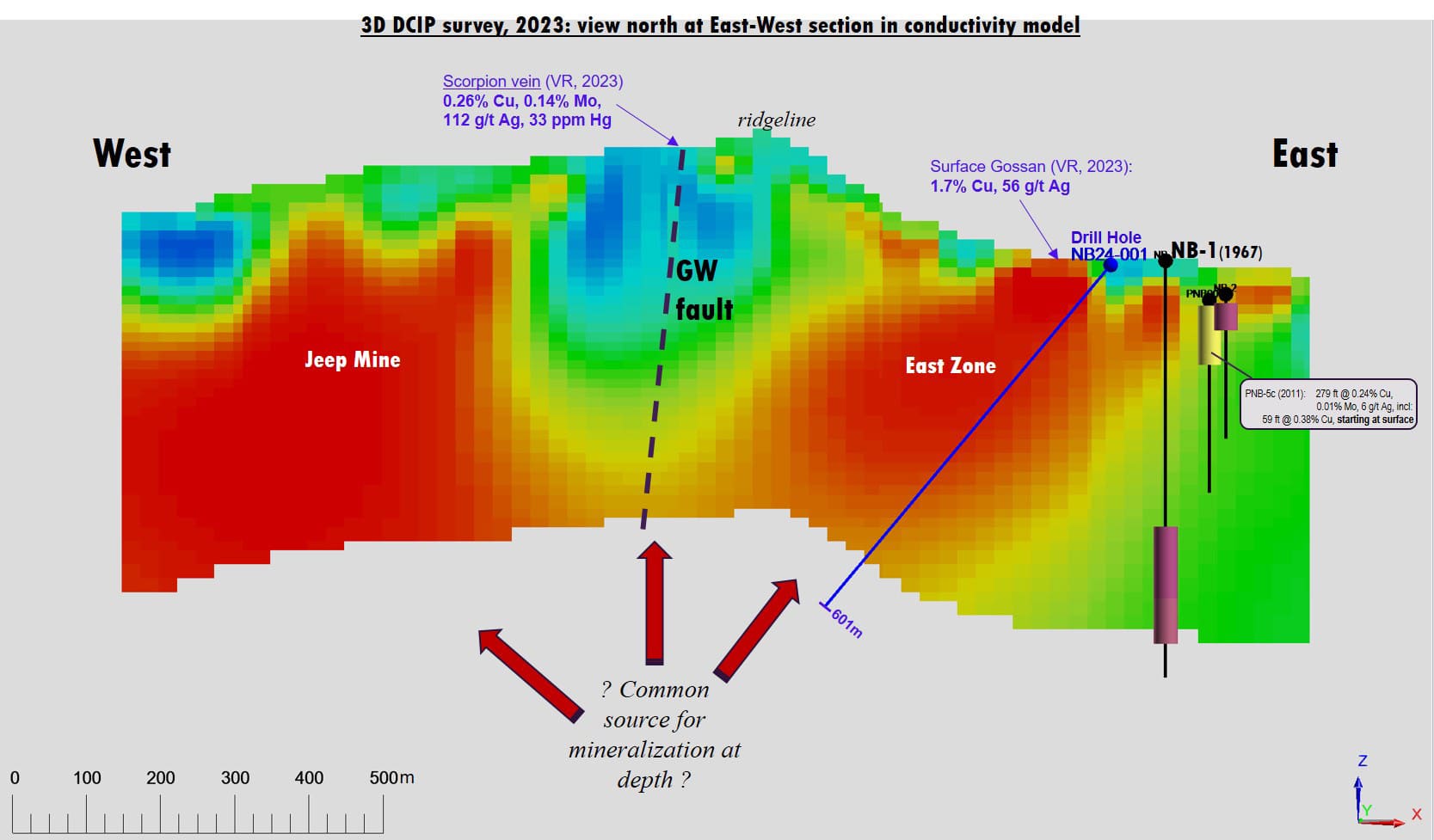
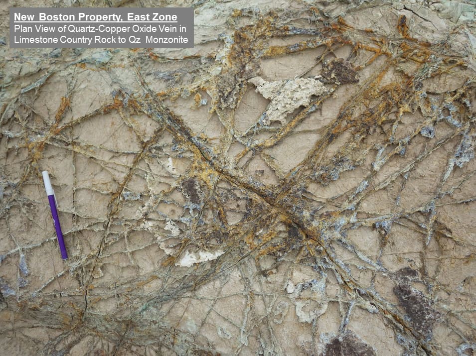
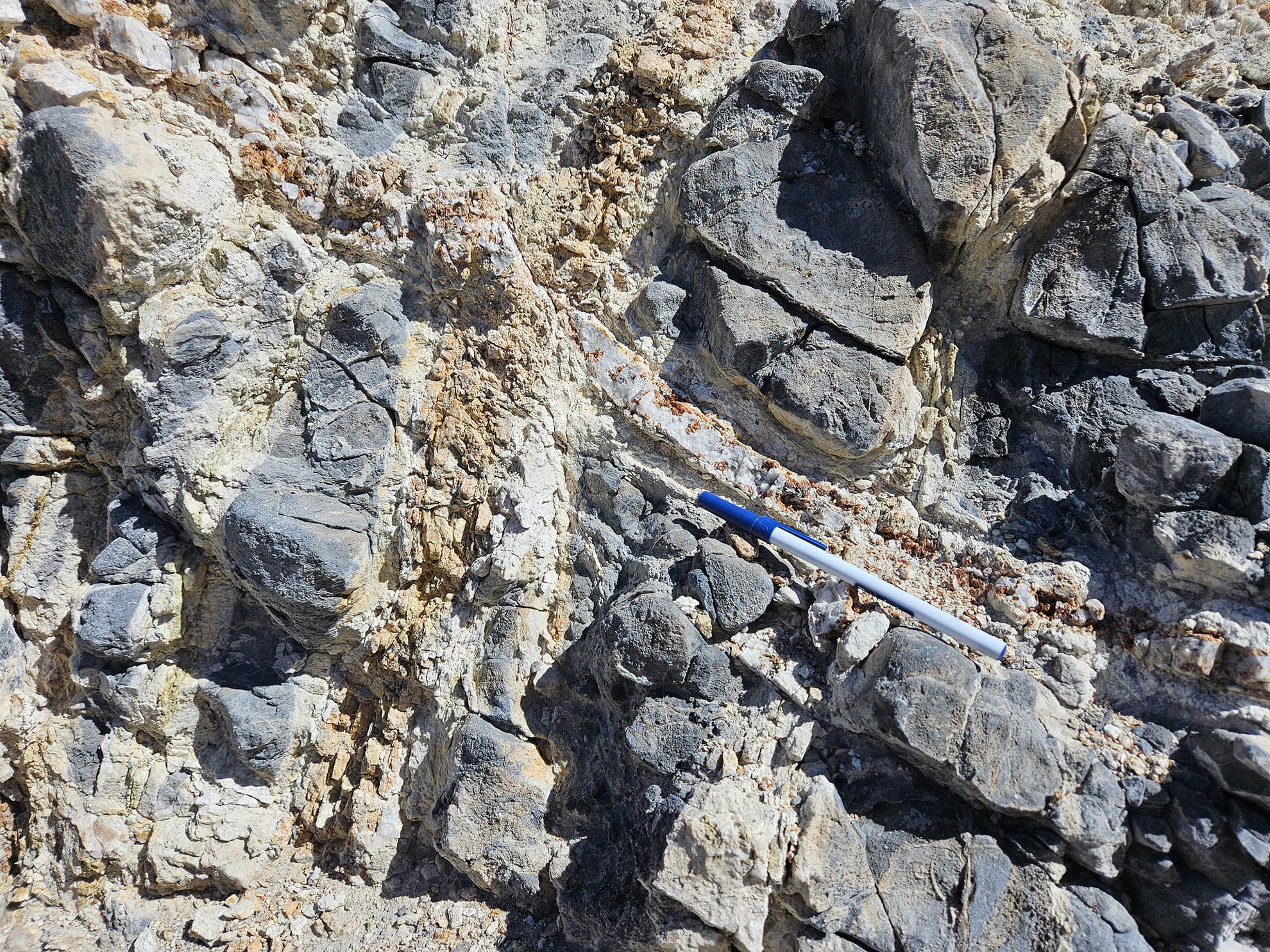
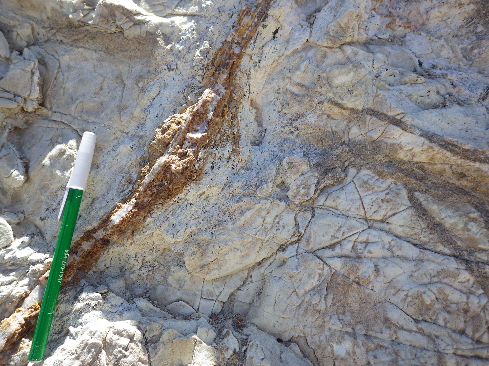
- GW boundary zone: GW boundary zone separates the large IP anomaly at Jeep Mine from the high amplitude conductivity anomaly at East Zone. It is based on geological mapping and sampling by VR throughout 2022 and 2023, and is supported by the new geophysical data derived from the magnetic, radiometric and DCIP geophysical surveys completed in 2023. The structure follows the topographic high of Jeep Mine hill where marbelization of limestone is strongest. The GS structure is itself mineralized; it forms a continuous gossan zone of more than one kilometre in length, with quartz veins and quartz vein stockworks with limonite and copper wad after massive chalcopyrite (copper sulfide), and silver values of up to 112 g/t in surface grab samples. Anomalies in copper and mercury are evident along GW in the grid-based, ICP-MS soil geochemical survey completed in 2010.
The new DCIP conductor at East Zone was drilled first, in the spring of 2024, based on it’s strong logistics via proximity to water source and easy access from Highway 95, and because there are no historic drill holes into this target, period. Further, from a geological perspective: 1. It is associated with known potassic alteration in porphyry dykes and stocks; 2. It is association with high temperature clay alteration minerals; 3. It is association with copper mineralization in gossans in the East Zone bowl where the conductor comes to surface. Supporting geochemistry from the East Zone include:
- Copper at surface. The core of the conductor comes to surface into a patch of maroon-coloured soil amongst hematite skarn and intense quartz vein stockworks, with up to 0.8% copper in soil;
- Historic peripheral copper intersections. A 2010 drill hole located 300m to the south of the conductor, up-dip in limestone, intersected 279ft @ 0.24% Cu from 12ft depth, coincident with a small conductor;
- Strike length. Starting from the maroon soil and surface geochemistry in copper in the eastern part of the bowl, the East Zone conductor plunges 900 m to the northwest, where it converges with the Jeep Mine conductor at depth.
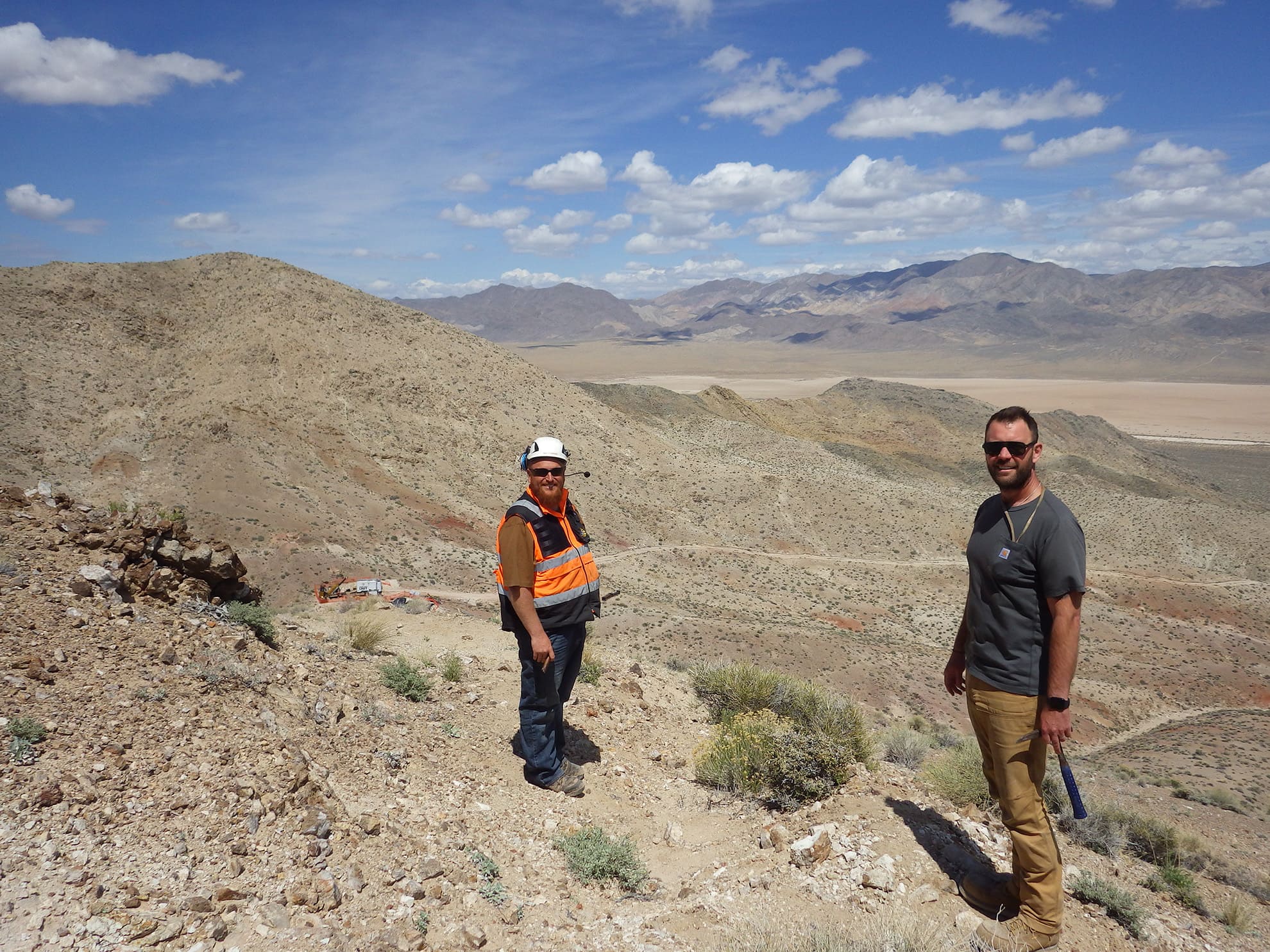
VR received its first NOI drill permit from the BLM for New Boston in October, 2023. VR then completed a site visit to New Boston in November; a short field video with the VP Exploration is available on this Project Page . The purpose of the trip was to meet with potential drill contractors in person in the field, and to discuss the logistics for the first-pass drill program planned for the East Zone conductor in the spring of 2024.
For strategic reasons, two separate NOI permit applications were prepared to cover both the large IP chargeability anomaly at Jeep Mine and the large conductivity anomaly at East Zone (EZ), respectively. The East Zone permit was submitted first, and was approved within 15 business days.
Drilling, Spring 2024.
Two reconnaissance drill holes were completed at East Zone on the eastern end of the polymetallic porphyry-skarn mineral system exposed on surface at New Boston in June, 2024, for a total of 1,310 metres. The two holes test the East Zone conductor identified in a state-of-the-art 3D array DCIP survey completed in 2023 along two different structural pathways for hydrothermal fluids. Overall, key attributes of the East Zone at the eastern end of the 3-4 km system of sheeted veins at New Boston include:
- There are bona fide polyphase stockwork vein geometries of quartz with copper sulfide exposed at surface at East Zone;
- There are bona fide dacite porphyry dykes together with quartz monzonite stocks exposed on surface at East Zone, and;
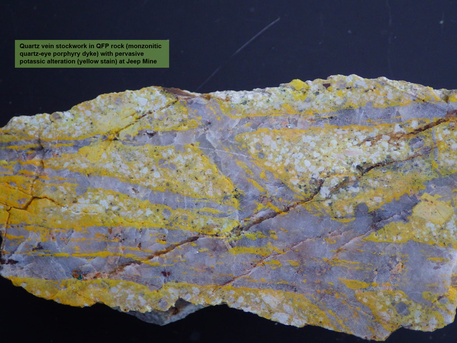
- There are bona fide high temperature potassic alteration mineral assemblages with potassium feldspar, biotite and magnetite.
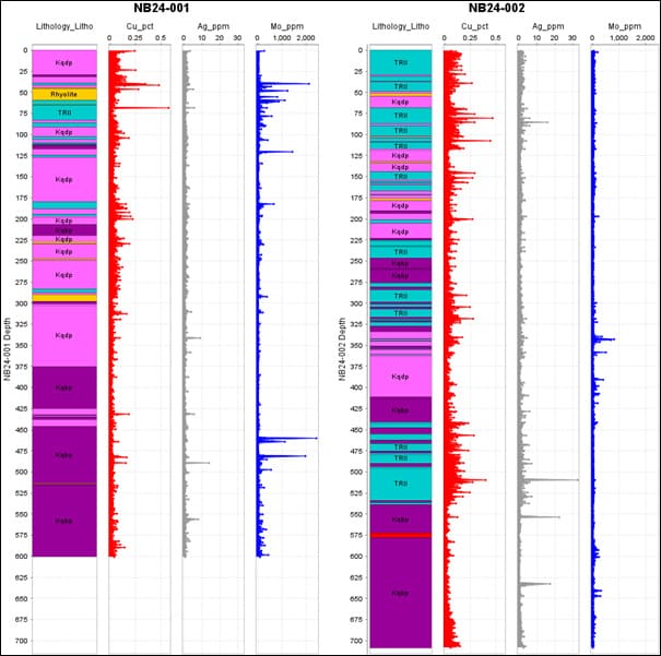
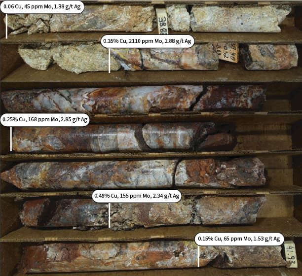
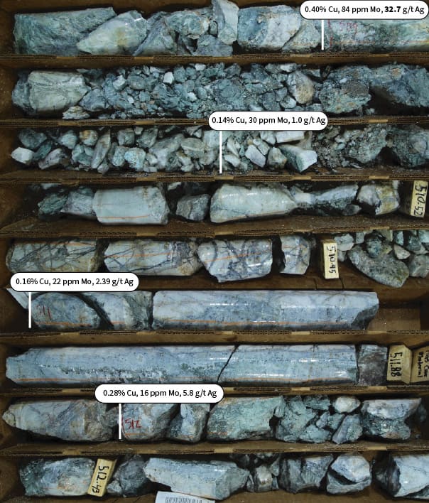
Results
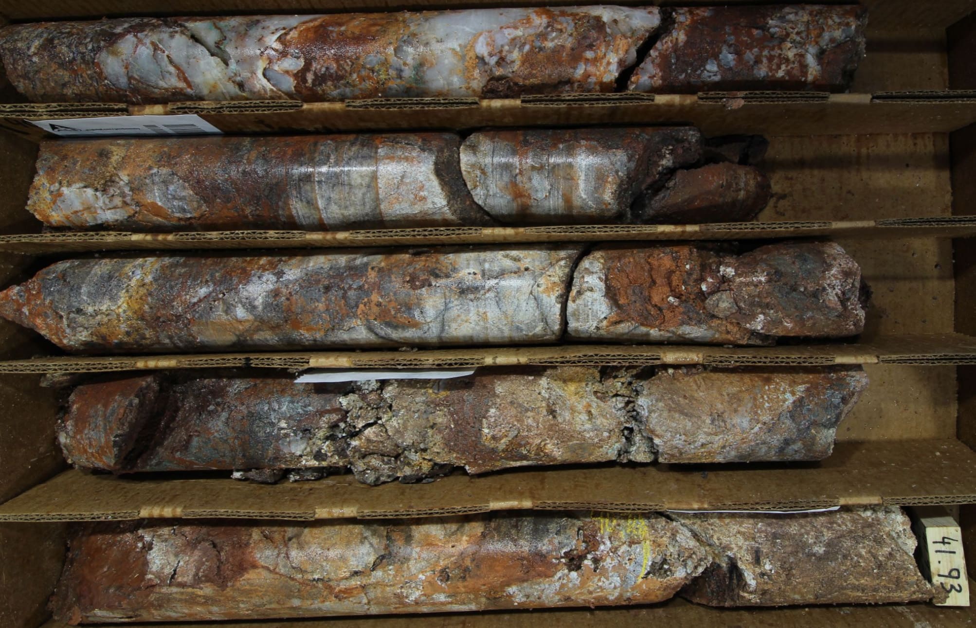
The drilling shows broad, continuous low-grade mineralization through the entirety of both drill holes, with local, higher grade intensity of copper up to 0.6%, and silver up to 33 g/t, in skarn mineralization within completely recrystallized limestone.
The drilling also confirms the polyphase nature of the New Boston porphyry system, with multiple phases of monzonite porphyry in both holes, each with distinct mineralization potential across the system exposed westward through to Jeep Mine.
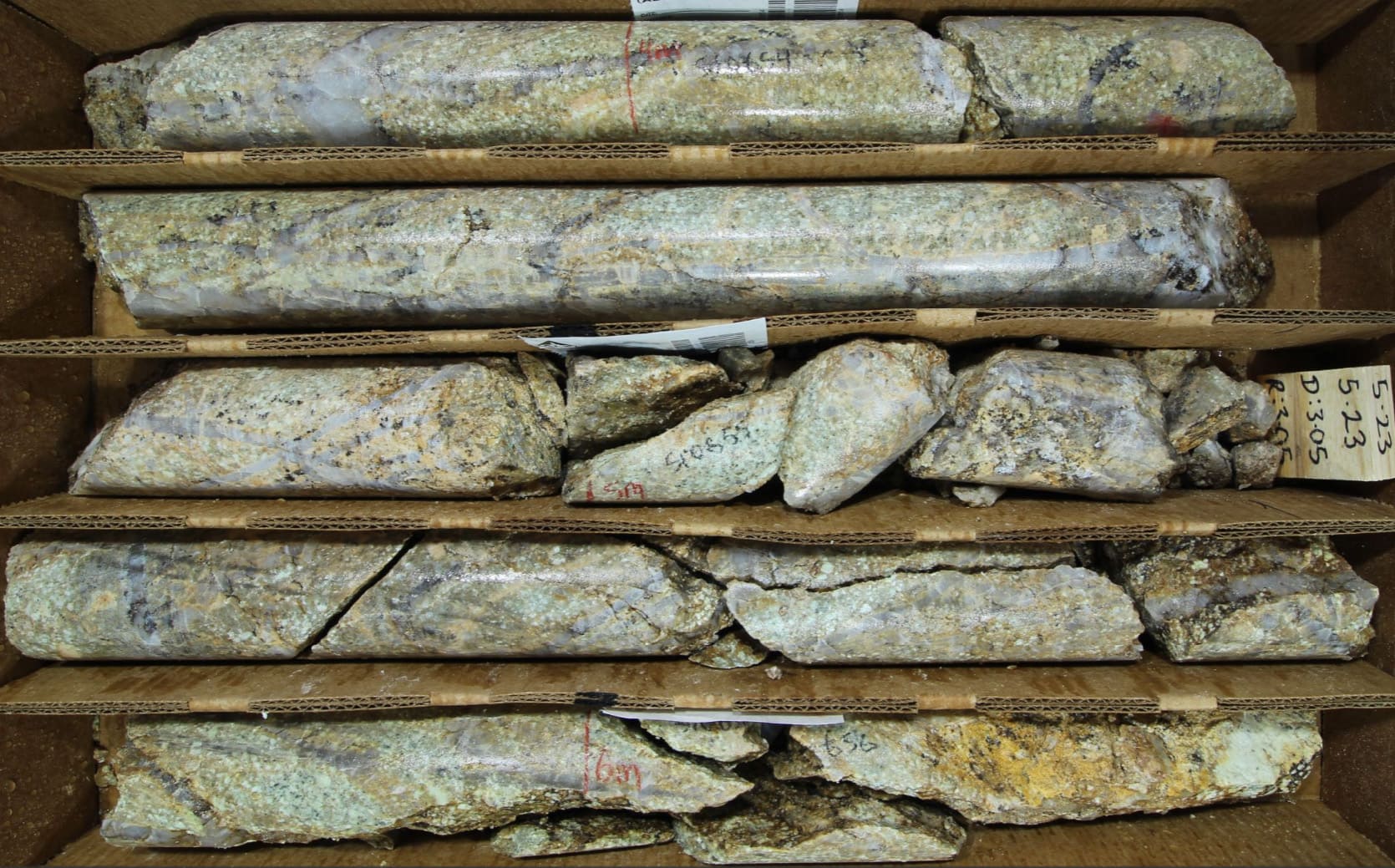
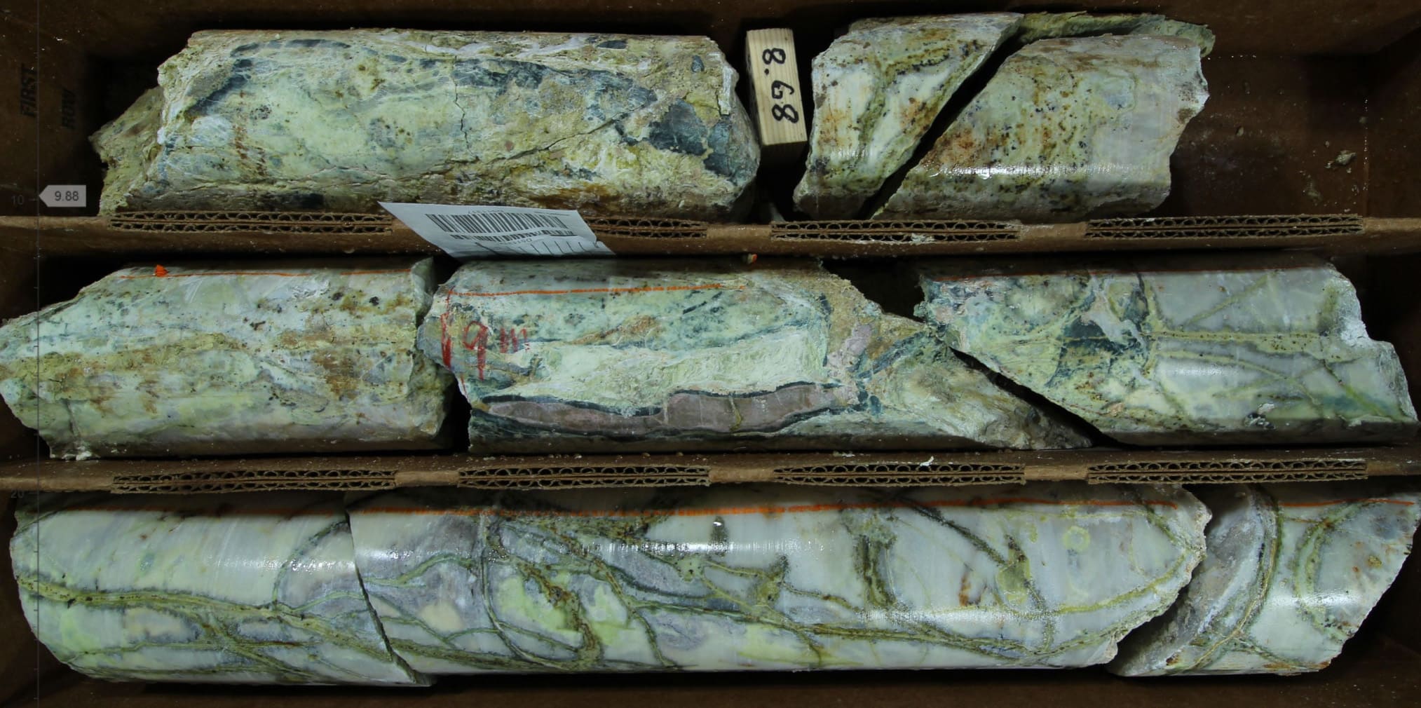
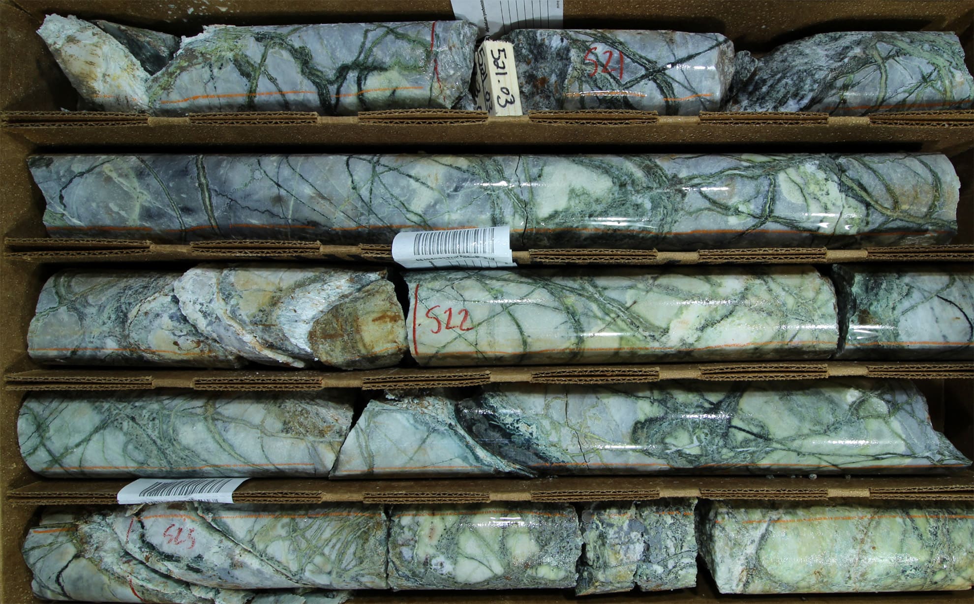
Continuous geochemical sampling of drill core was completed on both drill holes. The data demonstrate: 1. the sheer intensity and volume of porphyry-style stockwork veining that is continuous across some 601 and 709 metres of drill core respectively in both holes (see drill core photos on this Project Page), and; 2. Low grade but continuous copper mineralization with local silver mineralization over some 525 m in Hole 002.
Summary results include:
-
Continuous hydrothermal mineralization and potassic alteration starting
at surface.
- All 563 samples across 601 m (1,972 ft) in Hole 001 have hydrothermal mineralization. Copper averages 0.05% with max 0.60%, and 1.0 g/t Ag with up to 14 g/t, & 76 ppm Mo on average.
- All 620 samples across 709 m (2,326 ft) in Hole 002 have hydrothermal mineralization, Copper averages 0.07% with max 0.50%, and 1.5 g/t Ag with up to 32.7 g/t, & 35 ppm Mo on average.
-
Copper-moly-silver mineralization in limestone host rock.
- 48m @ 0.11% Cu, 115 ppm Mo & 1.55 g/t Ag from 0 m (surface) in Hole 001.
- 117.6m @ 0.10% Cu, 118 ppm Mo & 1.9 g/t Ag from 1 m in Hole 002.
- 98m @ 0.12% Cu, 24 ppm Mo & 2.3 g/t Ag from 441 m in Hole 002.
Going Forward into 2026
Current work for the New Boston Project is focused on refining drill targets for Jeep Mine on the west side of the system, in follow-up to the first leg of drilling at East Zone on the eastern side of the system in 2024. Further, we are engaged with an array of potential strategic partners to consider strategies to fund and advance the exploration. Finally, our permitting work is ongoing, to ensure compliance with environmental regulations.
With regards to drilling, we know what to do next. We continue to integrate geophysical, geochemical, and structural data sets to optimize drill hole locations for the drilling planned at Jeep Mine. The IP anomaly at Jeep Mine is large, and the coincident conductivity has greater conductivity at depth compared to East Zone, which itself lacks an IP response. Mineralized monzonite porphyry was encountered in the lower parts of both of our initial drill holes at East Zone, that is, down plunge in the westward plunging East Zone conductor, with grades increasing with depth in Hole 002 towards the central GW structure and the Jeep Mine IP envelope and conductor on the other side.
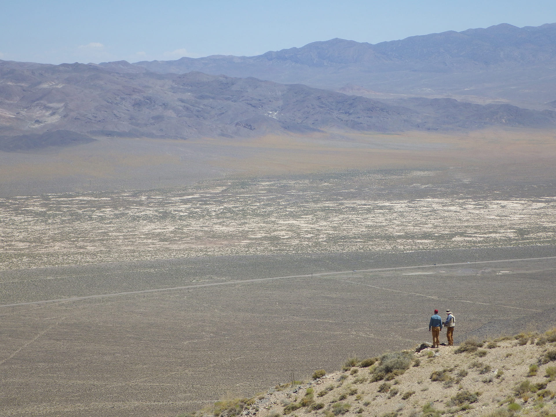
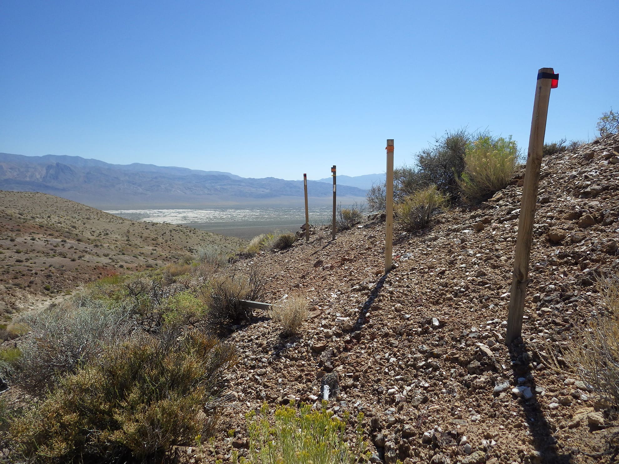
This data-driven approach ensures the next phase of modern drilling is optimized to test the most prospective zones for the strongest polymetallic molybdenum-tungsten-copper-silver mineralization at Jeep Mine, within the largest volume IP and conductivity expression within the expansive system of sheeted veins exposed on surface for some 3 – 4 km of strike at New Boston ( see annotated field panorama photo on this Project Page ).
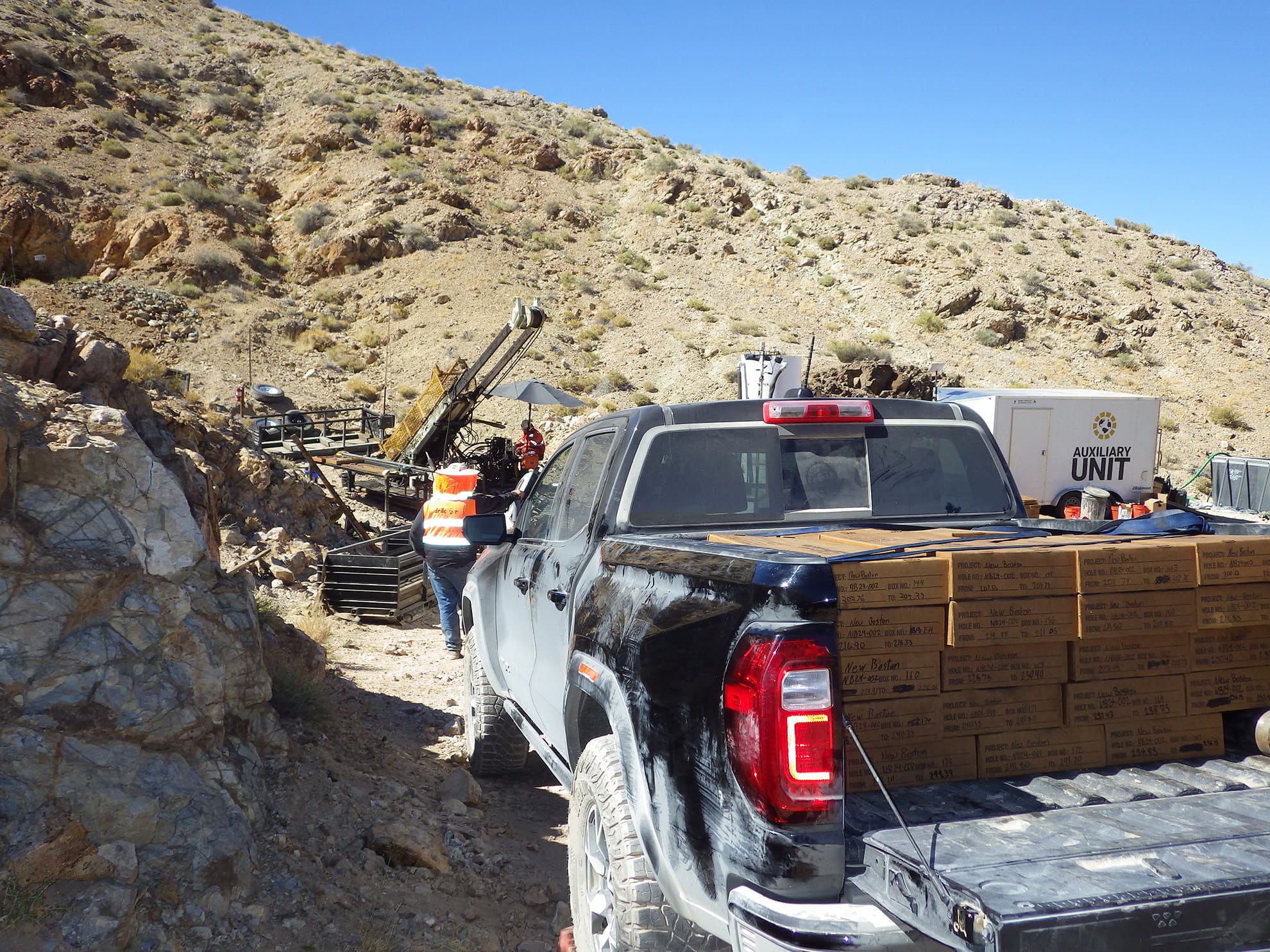
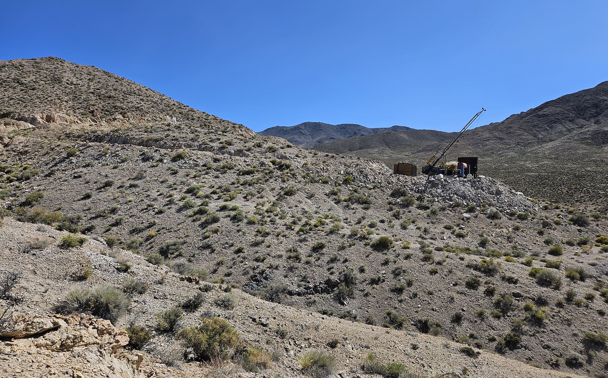
VR initiated the second leg of its reconnaissance drilling at New Boston in May, 2026, at Jeep Mine. Drill hole NB26-003 achieved a continuous vein and sulfide intersection across 2,892 ft (881 m) of drill core.
The Company will complete state-of-the-art, LWIR (long wavelength) and SWIR (short wavelength) hyperspectral mineral scanning of the entire hole at TerraCore Geospectral Imaging laboratories in Reno in order to map alteration minerals and identify alteration zonation across 2,892 ft of drill core. Also, high resolution, 8K photography of the entire drill hole will facilitate detailed mapping of complex vein geometries throughout the intersection.
The Company will apply state-of-the-art geochemical techniques at ALS Global laboratories, also in Reno, using digestion by sodium peroxide fusion to optimize detection of base metals and trace elements, especially tungsten and molybdenum which are hosted in refractory minerals. We believe this will be a first for New Boston’s historic exploration data base.
Hole NB26-003 is collared in a high temperature alteration zone of quartz-garnet stockwork veining. The hole is inclined steeply to the southeast, into and across the Jeep Mine hill in order to test the coincident geophysical anomalies which plunge steeply across a panel of north-dipping limestone and sheeted monzonite dykes with sheeted and stockwork veins with moly, tungsten, copper and silver mineralization which are exposed on surface at the drill collar. The intensity and continuity of veining in NB26-003 confirms the co-spatial, conductivity-chargeability anomaly in the Company’s 2023, 3D-array DCIP geophysical survey as the inferred sulfide center of the large-footprint polymetallic skarn and porphyry system exposed on surface at New Boston.
Initial observations and key take-aways from NB26-003 include:
- Continuity. Polyphase quartz veins with vein and disseminated sulfide logged in all core boxes across the 2,892 ft (881 m) intersection, from top to bottom of the hole;
- Breadth. NB26-003 did not drill through the target. The sub-vertical hole became unstable and was terminated at 2,892 ft, still in polyphase veins with sulfide in limestone completely recrystallized to marble and dolomitized marble, with clay-altered and sulfide-bearing porphyry intrusions;
- Intensity. There is no unaltered drill core. High temperature garnet skarn replacement and marbelization of limestone occurs throughout the hole. Hydrothermal alteration with vein and disseminated sulfide is logged in all rock types from top to bottom of the hole, including limestone, siltstone, and importantly, all intrusive porphyry phases as well;
- Energy. Vein geometries include: sheeted (parallel to bedding); sinuous/ptygmatic; stockwork; conjugate; planar crack-seal, and; vein breccia. Veins occur at all angles to core axis throughout the 2,892 ft intersection, from top to bottom of the hole;
- Polymetallic. Surface geochemistry at the drill collar site demonstrates moly, tungsten, copper and silver mineralization present in quartz-garnet veins in grey limestone recrystallized to marble. Sulfide mineral assemblages including pyrite, chalcopyrite and molybdenite in varying proportions and textures are logged in virtually every core box throughout the 2,892 ft hole, in veins with and without quartz, in vein breccia, and as disseminations;
- Source. There are numerous porphyry intrusive phases throughout the hole, importantly, themselves with quartz veins and vein and disseminated sulfide. There is more diversity in intrusive phases than is mapped on surface; they are the inferred driver of the expansive mineralized vein system exposed on surface over an east-west strike of 6,900 ft (2.1 km) at New Boston.
There are eight approved sites for drilling on the Company’s current NOI drill permit. Data from NB26-003 will facilitate prioritization of the various permitted sites for further drilling within the large-footprint alteration, vein, sulfide and intrusive center that is now evident in three dimensions at Jeep Mine.
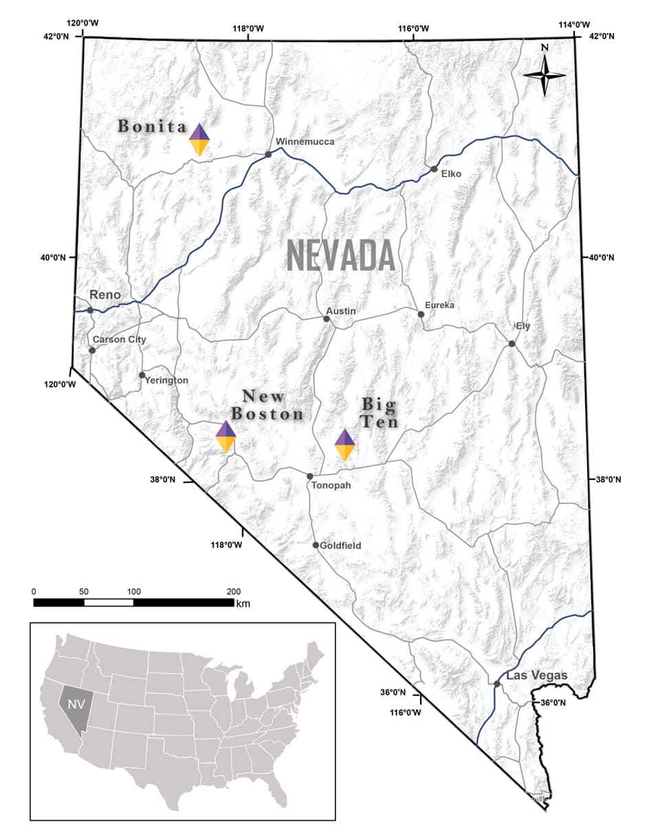
New Boston is located in Mineral County, approximately 150 kilometres southeast of Reno, Nevada.
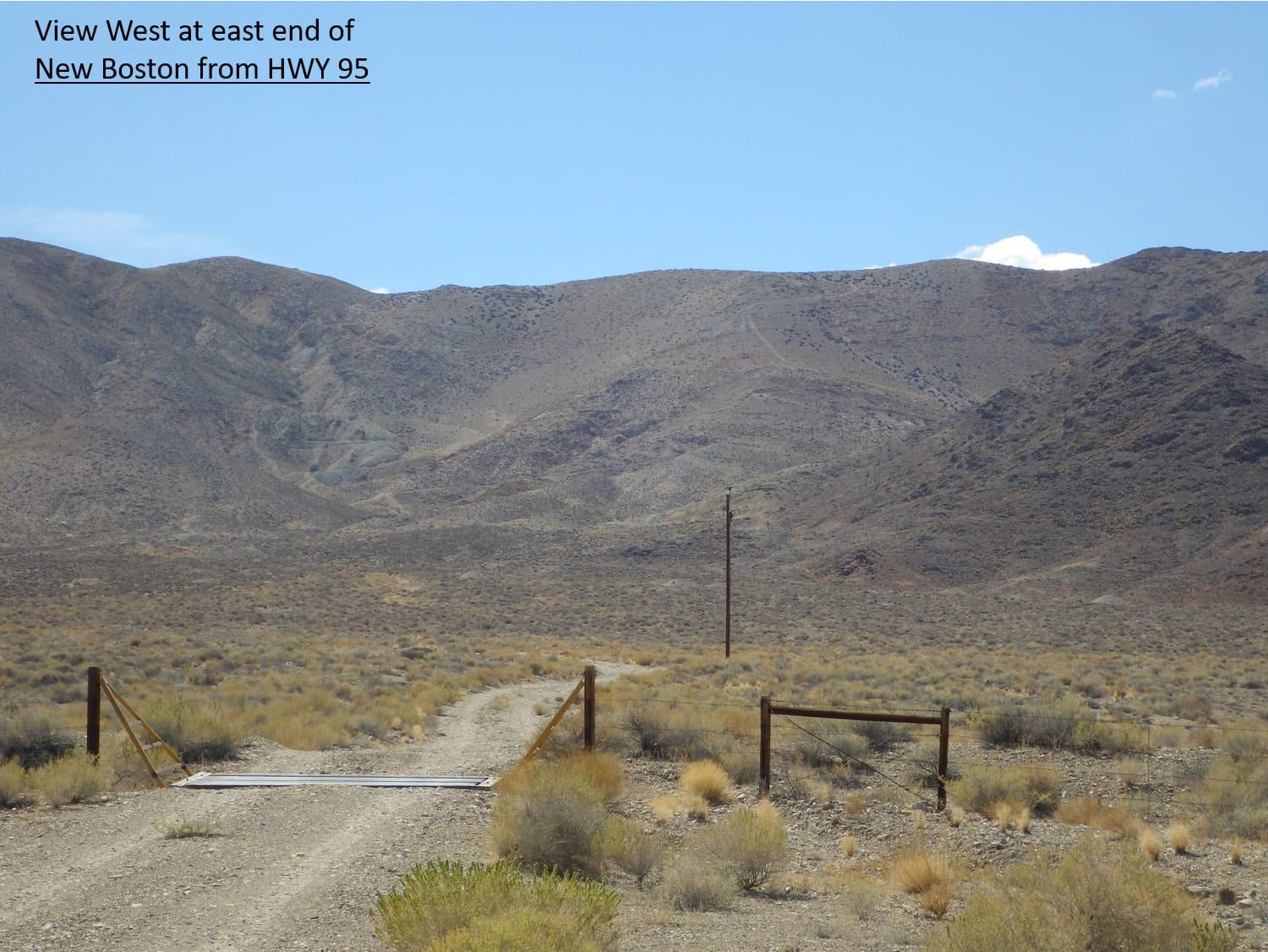
The property location affords both year-round and cost-effective exploration. Access is from the nearby town of Luning located just 5 km to the northeast, on HWY 95, with active rail and grid power. The property itself is criss-crossed by a myriad of old trails and roads, reachable from the highway.
Topography at New Boston is dominated by the Garfield Range; ridge lines are gentle but scree slopes are common. Overall, outcrop is extensive and vegetation is sparse at New Boston. Where outcrop is covered, colluvium is interpreted to be thin and local in nature.
Climate is semi-arid to arid, with hot dry summers and cold dry winters.
The New Boston property consists of 71 claims in one contiguous block covering 537 hectares (1,329 acres). It covers the entire porphyry-skarn system exposed on surface east of the artisanal workings at Blue Ribbon located at the western end of the overall porphyry-skarn system at New Boston.
The property is on federal land administered by the Bureau of Land Management (BLM). There are no state or federal land use designations, or privately-owned land which impedes access to the property, nor is the property within the BLM’s broadly defined area of sage grouse protection.
The property is owned 100% by VR. There are no underlying annual lease payments, nor are there any joint venture or back-in interests. The property vendor retains a royalty on the property, with a buy-back provision to VR.
The New Boston property is located in the Walker Lane structural belt and mineral district in west-central Nevada. The Walker Lane is transtensional in nature, related to right-lateral movement along the western margin of North America in Tertiary time. This grain is discordant to the dominant northeast grain of the Basin and Range extensional structures dominant to the east and north throughout Nevada.
Published ages on the quartz monzonite stock at New Boston range from 72 to 82 Ma (late Cretaceous), consistent with the age of other nearby porphyry deposits such as Hall, with a moly and copper resource delineated by Anaconda in the 1970’s while it’s nearby Yerington operation was active. There is current exploration on similar-aged moly-tungsten porphyry-skarn systems at Guardian Metals’ Pilot Mtn project located some 25 km to the southeast of New Boston, and American Tungsten’s IMA project in southern Idaho, located in the same Cretaceous porphyry belt which hosts the Thompson Creek moly porphyry deposit. Collectively, these Cretaceous porphyry systems were emplaced during a period of transpression and crustal extension which developed along the western margin of North America following convergence and related subduction through the early Mesozoic.
The oldest rocks exposed in the Garfield Range are a late Paleozoic marine succession of limestone and shale, commonly mapped as slate and marble. Permian mafic volcanic rocks occur at the top of the succession south of the property.
Deformed Paleozoic strata at the property are overlain by the Triassic Luning Formation. The shallow marine succession generally strikes east-west and dips moderately to the north. The shallow marine sequence of locally algal limestone is intercalated with crystal tuff, coarser lapilli tuff and tuffaceous siltsone which underlay limestone in the southern prat of the property, and argillite mudstone which overlies the limestone in the northern part of the property. The Jurassic Dunlap Formation is present south of the property, consisting of maroon siltstone and pebble conglomerate which have a “red bed” appearance overall. In this location, the Luning Formation strata have been thrust over the younger, north-dipping strata of the Dunlop during a late Mesozoic, south-vergent compressional event.
A central valley extensional fault, east-block down, bisects the middle of the property. It strikes north and is a low-lying area of pediment cover in between exposed ridges of colluvium on exposed, broken outcrop with little vegetation which is characteristic of most of the Garfield range. This late central valley fault at New Boston accommodated the extrusion of intermediate volcanic rocks including flows, tuff and breccia in the Pliocene.
The property itself is underlain by the Triassic Luning Formation, consisting of limestone with interbedded felsic tuff and argillite, which have been thrust over Jurassic redbeds of the Dunlap Formation to the south. The Luning Formation is intruded by numerous quartz monzonite porphyry dykes and sills of presumed Cretaceous age.
Monzonite and quartz monzonite plugs and concordant sills intrude the Triassic limestone succession. Monzonite is pink weathering, and medium grained, dominated by mm-scale plagioclase and cm-scale orthoclase phenocrysts. Quartz phyric textures in lighter weathering dacite porphyry are evident on the east side of the property. Colour index in both rocks is very low, biotite is the primary mafic and magnetite is generally absent. Radiometric age dates from 1979 using K-Ar systematics on hornblende and biotite in quartz monzonite range from 79 to 82 Ma (late Cretaceous), respectively.
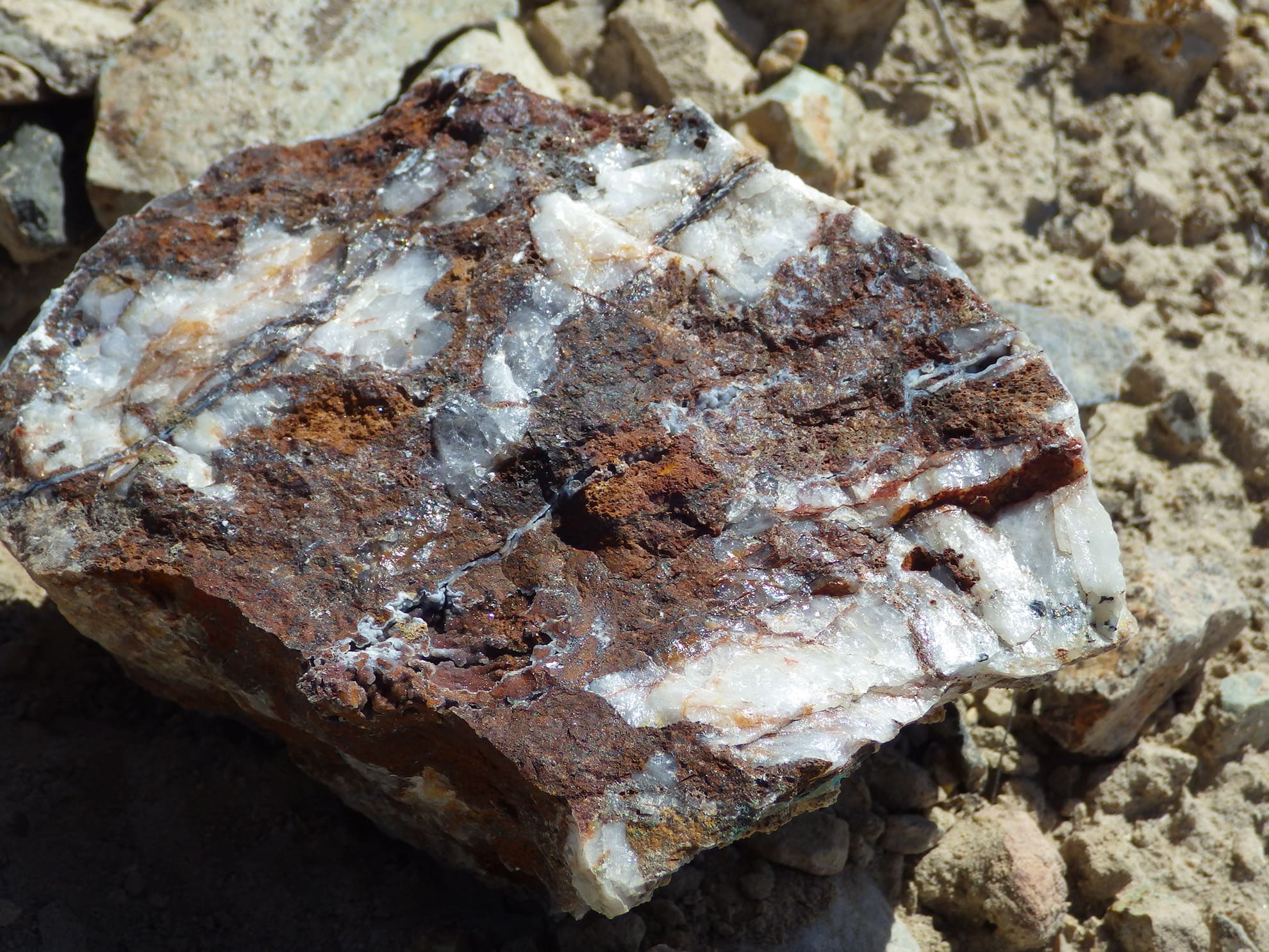
Potassic alteration (hydrothermal k-spar and shreddie biotite) is evident in quartz monzonite at Jeep Mine and dacite porphyry at East Zone, associated with quartz vein stockworks. Clay-alteration of plagioclase is mapped locally at East Zone, but argillic alteration is not well developed in the low – pyrite system. Alteration in country rock limestone ranges from patchy marbelization to wholesale recrystallization across the entire 4 km breadth of sheeted veins on the property, with wollastonite, garnet and diopside in vein assemblages at Jeep Mine and at East Zone. Clay alteration of the tuffaceous unit is evident at CCT Zone and farther South at Kay Mine, with copper oxide after copper sulfide in disseminated clots and decimeter-scale veins of quartz.
Pre-existing Paleozoic and Mesozoic fold and fault structures localize hydrothermal fluids and mineralized veins related to emplacement of the monzonite stock into the deformed early Mesozoic limestone stratigraphy in Cretaceous time.