Ranoke Project
KSZ Strategy (IOCG),
Northern ON
Projects
-
Critical Metals, Ontario
-
Porphyry Copper, Nevada
-
Precious Metals
-
Diamonds
Ranoke Project
The Company’s ongoing critical metals exploration strategy of the Kapuskasing Shear Zone (“KSZ”) in northern Ontario was initiated in 2018. Our discovery of cobbles of specularite breccia with sulfide in the Mattagami River in 2018 led to the intersection of specularite vein breecia and fluorite-carbonate veins in our first reconnaissance drill program at our Ranoke property. The subsequent discoveries of REE-bearing apatite in an IOA system with carbonatite at the Hecla-Kilmer property, and then diamond-bearing kimberlite at the Northway property together highlight the multi-commodity discovery potential of the KSZ district.
The exploration strategy is focused on identifying covered, and previously unrecognized hydrothermal-magmatic mineral systems with critical metals like copper and gold that are associated with the deep crustal structures of the KSZ. Exploration targets in the KSZ district are generally associated with regional-scale magnetic and/or gravity features coincident with anomalies in regional geochemical surveys. To successfully pursue blue-sky discoveries in a district covered by a blanket of glacial till, VR leverages:
- State-of-the-art exploration technologies.
- Modern IOCG mineral deposit models.
- In-house expertise in big data, using AI and machine learning to analyze large data sets from regional geophysical and geochemical surveys, and;
- In-house expertise for cost effective exploration in northern Ontario.
The recent sale of VR’s REE discovery at the Hecla-Kilmer property (“H-K”) highlights the success of VR’s KSZ strategy.
Location matters. The area is remote, and targets are covered by a regional blanket of till, yet there is strong regional infrastructure, including active rail, provincial grid power and highway access to Otter Rapids, all of which collectively enable cost-effective exploration, and will enhance project development going forward should a discovery be made.
Relevance. VR’s REE project and discovery in carbonatite vein breccia at Hecla-Kilmer that was recently sold to Neotech Metals Corp. was awarded in each year of the first four years of the Junior Exploration Grant Program for critical metal exploration in Ontario, “OJEP”, starting in 2021. The program is ongoing, and is now in Year 5. Hecla-Kilmer demonstrates the relevance of new critical metal discoveries in the KSZ district to policy initiatives from both provincial and federal governments which aim to catalyze the development of new domestic supply chains for mineral resources which can feed domestic, down-stream industries and sustainable technologies in response to the green economy, and as national economies respond and adjust to tariff-based agendas.
Below are summary descriptions of different aspects of the overall KSZ exploration strategy, followed by a more detailed summary of VR’s initial KSZ property named Ranoke. The kimberlite breccia pipe discovery at Northway is described separately and in detail on the Northway project page.
The Kapuskasing Structural Zone is a Proterozoic failed rift. It is a crustal-scale feature zone more than 200 km long that bisects the Archean Superior craton between James Bay and Lake Superior, forming a complex, northeast-southwest trending structural corridor of uplifted, high grade metamorphic rocks. There is believed to be more than 20 kilometres of vertical crustal displacement along the KSZ.
The KSZ hosts numerous alkaline, ultrabasic and carbonatite intrusions, kimberlite breccia pipes and lamprophyre dykes which span more than 1.7 billion years of activity, to as recently as 128 million years ago. This tectonic setting is prospective for the development of a large IOCG – IOA, and/or carbonatite-hosted hydrothermal breccia systems with critical metals, including copper and gold, and rare earth elements (REE) in carbonatite such as at the multi-phase alkaline-ultramafic intrusion at Hecla-Kilmer.
Hecla-Kilmer’s uniquely REE-enriched apatite mineralization in carbonatite vein breccia belongs to an iron oxide - apatite (IOA) hydrothermal mineral system which forms at the higher temperature end of the IOA – IOCG spectrum of mineral systems. Within this framework, our primary focus continues to be on the potential of the KSZ to host large, iron-oxide copper-gold (“IOCG”) mineral systems.
And in terms of structure, it’s about more than just one big crack in the earths crust along the KSZ. Both the Hecla-Kilmer alkaline and carbonatite intrusive complex and the Northway kimberlite breccia pipe occur at the convergence of multiple regional tectonic structures. More specifically, they occur along the western margin of the KSZ where it intersects the opposing tectonic suture boundaries on either side of the meta-volcanic Wabigoon sub-province within the Archean Superior Craton, with the sediment-dominated Quetico province to the south, and the English River sub-province to the north. For the Northway kimberlite discovery, it is also noteworthy that the gneissic crystalline basement of the English River sub-Province is believed to be the thickest part of the Archean Superior craton, period.
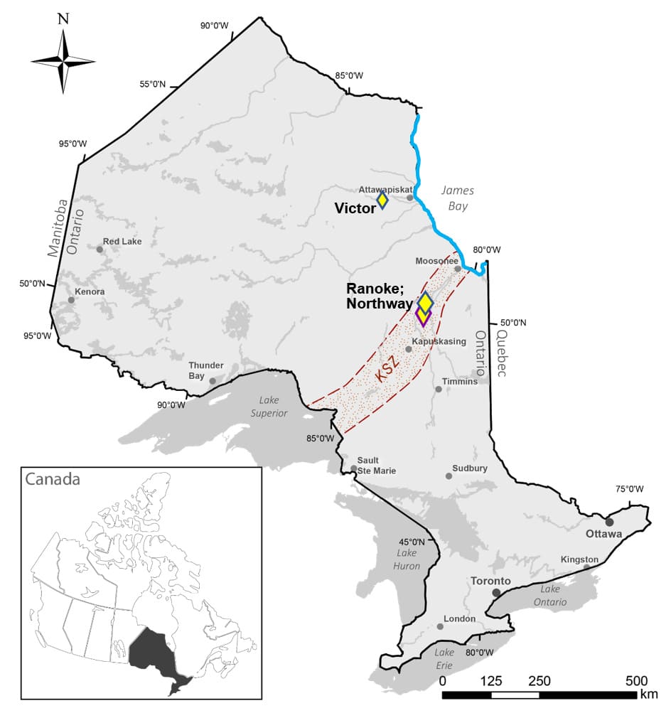
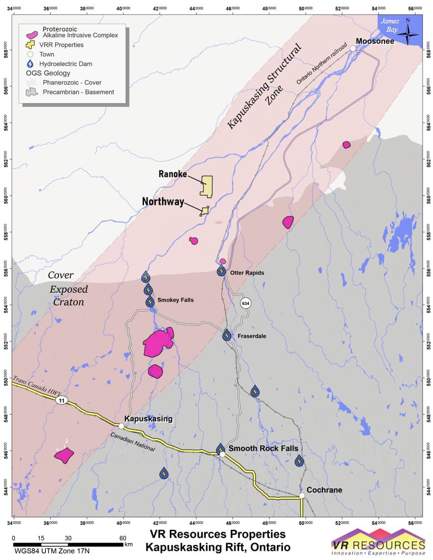
The KSZ properties are located in the Moose River basin in northern Ontario, Canada. The Ontario hydro-electric facility at Otter Rapids serves as the northern terminus of Highway 634 which links the region to the towns of Cochrane and Kapuskasing situated on the northern Trans-Canada Highway located approximately 100 km to the south.
To the north is the town of Moosonee about 150 km north-northeast of Otter Rapids, and located on tidewater at James Bay. The Ontario Northern railway connects Moosonee with the mainline at Cochrane along the Trans Canada Highway, and is central to VR’s KSZ strategy overall; the Northway kimberlite breccia pipe discovery is located, for example, just 15 km to the west of the active rail service.
Near-by towns on the Trans Canada highway, and road access with grid power to Otter Rapids, facilitate cost-effective exploration for the KSZ strategy.
Subdued topography is optimal for airborne geophysical surveys such as EM and magnetics. Historic drilling demonstrates that overburden thickness is in the range of 20 – 70 m, average for the region and easily penetrated by modern drilling technology. Historic drilling in the region was focused on base metals in the 1970’s, and on kimberlites and diamond exploration in the 1980’s. Some 40 years later, VR has taken the opportunity to be the first company to apply new exploration technologies and modern mineral deposit models to explore the region for large footprint IOCG, IOA and kimberlite breccia bodies and mineral systems. Work completed to date which has seeded the early discoveries at Ranoke, Hecla-Kilmer and Nothway includes:
- VR has completed the compilation, synthesis and interpretation of all available federal and provincial government regional data, and archived provincial mineral exploration assessment data in the KSZ district.
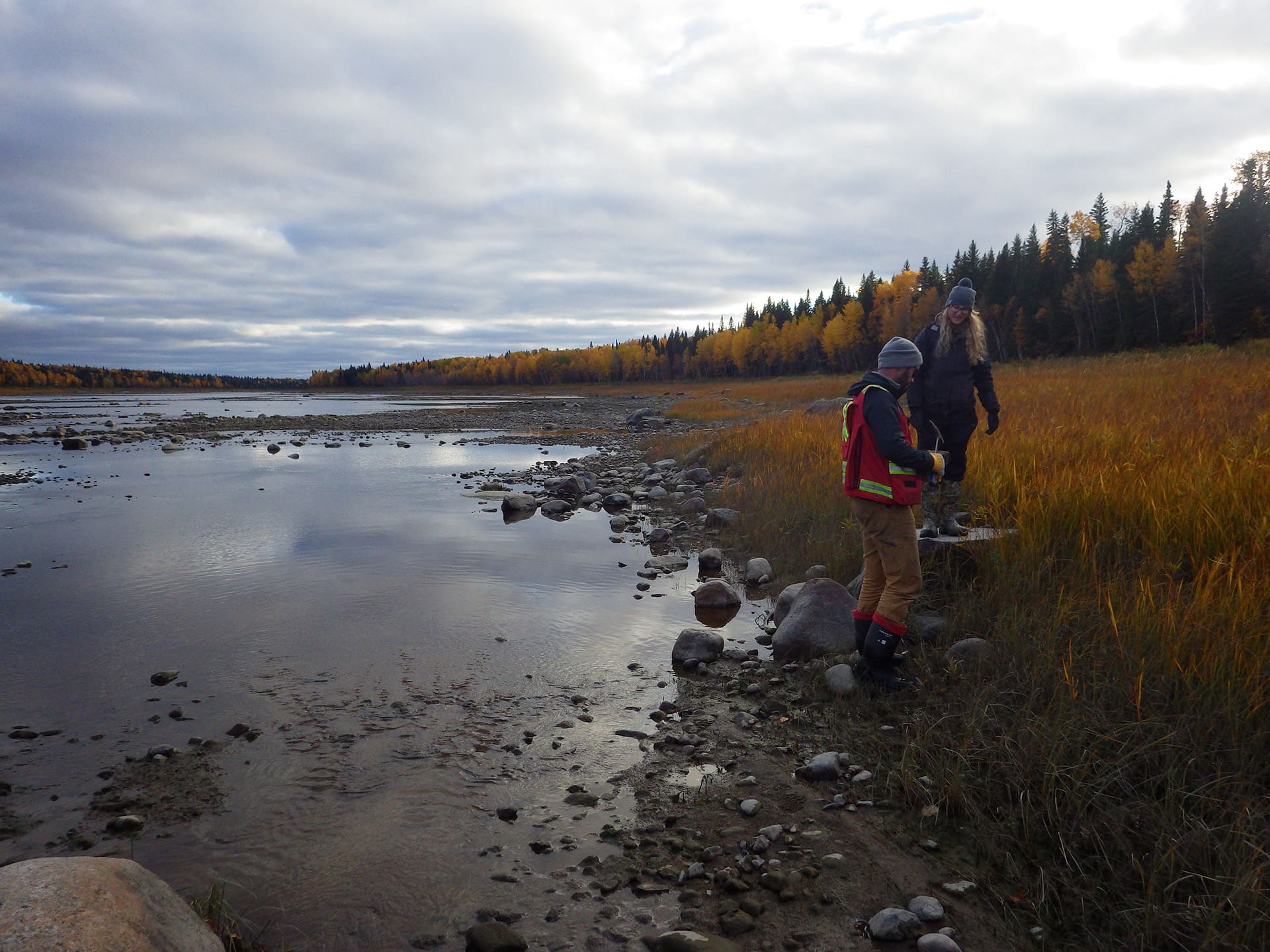
- Ground-based gravity and state-of-the-art soil gas surveys were completed at the Ranoke property in 2019.
- The Company completed the first-ever airborne EM survey ever over the Hecla-Kilmer alkaline-ultramafic intrusive complex with carbonatite in June, 2020, using the state-of-the-art VTEM+ system of Geotech Ltd. The Company also had an independent, 3-D inversion of both magnetic and EM data completed for improved modeling for a potential magnetite-fluorite hydrothermal breccia body within the multiphase carbonatite complex. The Company also utilized a pre-existing, high-resolution, fixed wing airborne magnetic survey completed in 1993 by High Sense Ltd. as part of a regional diamond exploration program to improve the magnetic modeling.
- A detailed, ground-based gravity geophysical survey was completed at Hecla-Kilmer in March, 2021. It covers an area of approximately 1.5 x 3.5 km, with 597 stations completed in total; 573 on an equant grid station spacing of 100 metres, and 24 done on a 50 m infill pattern covering the main anomaly after it had been outlined by completion of the main grid. A modern inversion of integrated gravity and magnetic data sets was completed to evaluate structural controls for mineralization, and refine drill targets.
- An ultra – high resolution, state-of-the-art drone magnetic survey was flown in the fall of 2021, and expanded in March of 2022, when the Northway property was also flown. The objective of these surveys is to: 1. clearly define the external boundaries of the overall complex, and; 2. identify internal magnetic contacts and gradients that are discordant to the magnetic zonation related to the primary igneous emplacement history of the multiphase complex, and are therefore potential targets for secondary hydrothermal veins and breccia with critical metals.
- Reconnaissance drilling was commenced at the Ranoke property in 2020 with a three-hole winter drill program completed immediately prior to the COVID 19 global pandemic.
- Some 23 holes were completed in five successive drill programs at Hecla-Kilmer, upon the discovery of REE-enriched apatite in carbonatite vein breccia within the multi-phase alkaline complex, which in turn led to the discovery of the Northway kimberlite breccia pipe located approximately 20 km to the north of Hecla-Kilmer, where three reconnaissance holes are complete, all with diamond fragments (see Northway Project Page on this website).
- Real-time, on-site XRF scanning of drill core was utilized at Hecla-Kilmer; laser ablation ICP-MS was completed on select drill core samples by SGS Laboratories for detailed REE mineralogy, and; REE distribution at the mineralogy scale was analyzed using a scanning electron microprobe (EMPA) equipped with an Energy Dispersive Spectrometer (EDS) on select samples of carbonatite vein breccia.
The project area is at the southeastern margin of the mid-Paleozoic Hudson shelf, a shallow marine carbonate shelf success from Ordovician to Devonian age, with local sandstone and evaporate facies. The shelf formed directly on crystalline basement rock. The Moose River sub-basin developed on the southeastern-most margin of the shelf where Devonian strata. It is a small successor basin less than 50 kilometres across and preserved as finely laminated and poorly indurated mudstone and siltstone which formed in the area of the present-day Moose River, immediately to the north of Hecla-Kilmer. These Devonian and Cretaceous strata in the Moose River area were deposited on a gneissic crystalline basement of metamorphosed sedimentary assemblages and lesser volcano-plutonic complexes of the Archean English River domain in what is believed to be the thickest part of the Superior craton in northern Canada.
As such, sedimentary cover increases to the north of Hecla-Kilmer, thus covering basement rocks and targets at the Northway and Ranoke properties. Conversely, to the south of Hecla-Kilmer at Halfway, not only is there no sedimentary cover above basement, glacial till is only twenty metres thick, substantively half what it is at H-K.
The opportunity for VR is to be the first company to apply modern IOCG - IOA, carbonatite and kimberlite mineral deposit models to the northern KSZ district, and be the first to utilize modern exploration technologies to improve the exploration for REE’s, critical metals, copper and gold in a region covered by a blanket of glacial till.
Historic exploration in the Moose River Basin region has been hindered by limited access, and a complete lack of outcrop in the lowland terrain that is covered by a regional blanket of glacial till. Archean VMS and Proterozoic orogenic gold deposits occur in the surrounding sub-provinces of the Superior craton, but there are no historic or currently active base metal or precious metal mines in the Moose River Basin.
The Moose River region has a long and varied, if not sporadic checkerboard history of mineral exploration during the past 100 years.
Overall, Cretaceous coal seams were the focus at the turn of the previous century, the basement unconformity at the base of the Paleozoic shelf was the focus for base metal exploration in the 1970’s, and there was active diamond exploration through the 1980’s and 90’s, extending and eventually focusing in the region west of James Bay at Attawapiskat located some 350 km to the north of Hecla-Kilmer, off the western shores of Hudson Bay.
There are lignite occurrences exposed in the banks of the Abitibi River north of Coral Rapids. The coal seams were first studied in detail by the Geological Survey between 1871 and 1912. They extend westward from the Abitibi River within the confines the Cretaceous Moose River Basin. More than one hundred shallow drill holes were completed by the Ontario Department of Mines between 1926 and 1930 to evaluate the resource, leading ultimately to the completion of two shafts and some 389 metres of interconnecting drifts. Drilling resumed in the early 1950’s with the completion of an additional 182 holes. In 1981, the Ontario Energy Corporation re-visited the potential of the coal and evaluated lignite stratigraphy farther to the west. Hundreds of shallow drill holes were completed on a lease which exceeded 1 million acres.
The Aquitane Company of Canada Ltd. completed airborne and ground geophysics between 1972 and 1974 to evaluate the hydro-carbon potential of Paleozoic strata, and twelve diamond drill holes to test for base metals at the basement unconformity, and MVT-style mineralization in the overlying limestone. In 1978, Kerr-Addison Mines complete a series of reverse circulation drill holes near Coral Rapids to test exposed basal sandstone at the eastern edge of the Hudson Platform for uranium. These targets were re-visited and re-tested in 2006.
Six diamond drill holes were completed at Hecla-Kilmer by Ashland Oil and Elgin Petroleum in 1970, as part of a regional base metal exploration program. One hole was abandoned, and a scant 854 m were completed in five other holes, all on magnetic highs in the outer zones of the H-K complex. Importantly, this historic drilling showed that the H-K carbonatite complex comes to bedrock surface at the base of till, typically around 40m depth, with no intervening Paleozoic or Cretaceous sedimentary strata.
Diamonds were the focus of modern mineral exploration in the James Bay region. Exploration started in the 1960’s by DeBeers (Monoprose Canada), focused initially in the Attawapiskat River region well to the north of the Moose River Basin, and built on the pioneering regional aeromagnetic program of the Geological Survey of Canada. Ongoing and extensive regional till and alluvium heavy mineral sampling and high-resolution magnetic surveys through the late 1980’s eventually led to the discovery of numerous kimberlite pipes, including Victor.
Selection Trust (later named Selco Exploration Company) began alluvial sampling in the KSZ region in 1962, and were joined by Esso Minerals in 1979. The first composite kimerlite – lamprophyry dyke was drilled in 1967, followed by drilling of the Valentine carbonatite complex in 1969. Between 1979 and 1983, the Selco – Esso partnership completed regional heavy mineral sampling of till and alluvium over an area exceeding 100,000 hectares, and an aeromagnetic program launched in 1980 led to the identification of numerous post-Paleozoic, pipe-like anomalies, of which 45 were drill-tested; most were non- copper-bearing, ultra-basic and alkaline intrusions, and four were kimberlite-facies diatremes.
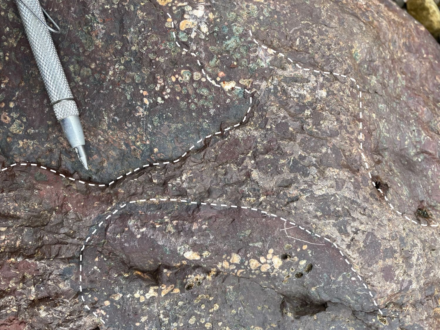
Selco completed two drill holes on magnetic highs peripheral to Hecla-Kilmer during their regional kimberlite exploration program. The two holes intersected altered, variably magnetic, dark green and dark red breccia with pervasive secondary chlorite and biotite respectively, disseminated sulfide, and mottled pink granitoid clasts with alteration rims. The mafic breccia is pervaded by a chaotic network of carbonate veins and carbonate-lined fractures in both holes.
Regional-scale exploration in the KSZ - Moose River Basin region waned after 1983. Various small-scale airborne magnetic surveys and ground-based EM surveys, and local alluvium sampling programs were completed at the property-scale between 1983 and 2006, with the focus mostly on previously known, ultra-basic and alkaline intrusions and diatremes exposed at surface in and around Coral rapids, but also on limestone for industrial mineral applications.
A regional-scale but high-resolution airborne magnetic survey was flown for diamond exploration in 1993, extending southwest from James Bay. The survey shows clearly that Hecla-Kilmer is a concentrically zoned, high contrast magnetic anomaly 4 – 6 km across. Easterly and northwesterly trending structures disrupt magnetic and gravity patterns within the complex.
The historic drilling at H-K in 1970 was done before the high-resolution magnetic survey was flown for diamond exploration in the early 1990’s, and before the development of IOCG-IOA mineral deposit models. This helps to explain why all five holes at H-K in 1970 were located in the outer concentric zones of the complex, why they were terminated at very shallow depth, and why there is no record of geochemical sampling or geochemical data in hydrothermal breccia with fluorite and sulfide which are documented in the drill logs.
The Ranoke copper-gold project is located in northern Ontario, Canada. Staked by VR directly, the Ranoke property extends the Company’s platform of blue-sky exploration on large-footprint copper-gold systems using new exploration technologies and modern mineral deposit models.
The Ranoke Property is located immediately north of a robust copper-gold-fluorite heavy mineral anomaly evident in several rivers in the Coral Rapids area, based on a regional alluvium survey completed by the Ontario Geological Survey in 2001 and 2002. The unique mineral assemblage underscores the potential for a buried IOCG deposit (iron oxide – copper - gold) as the source of the geochemical anomaly.
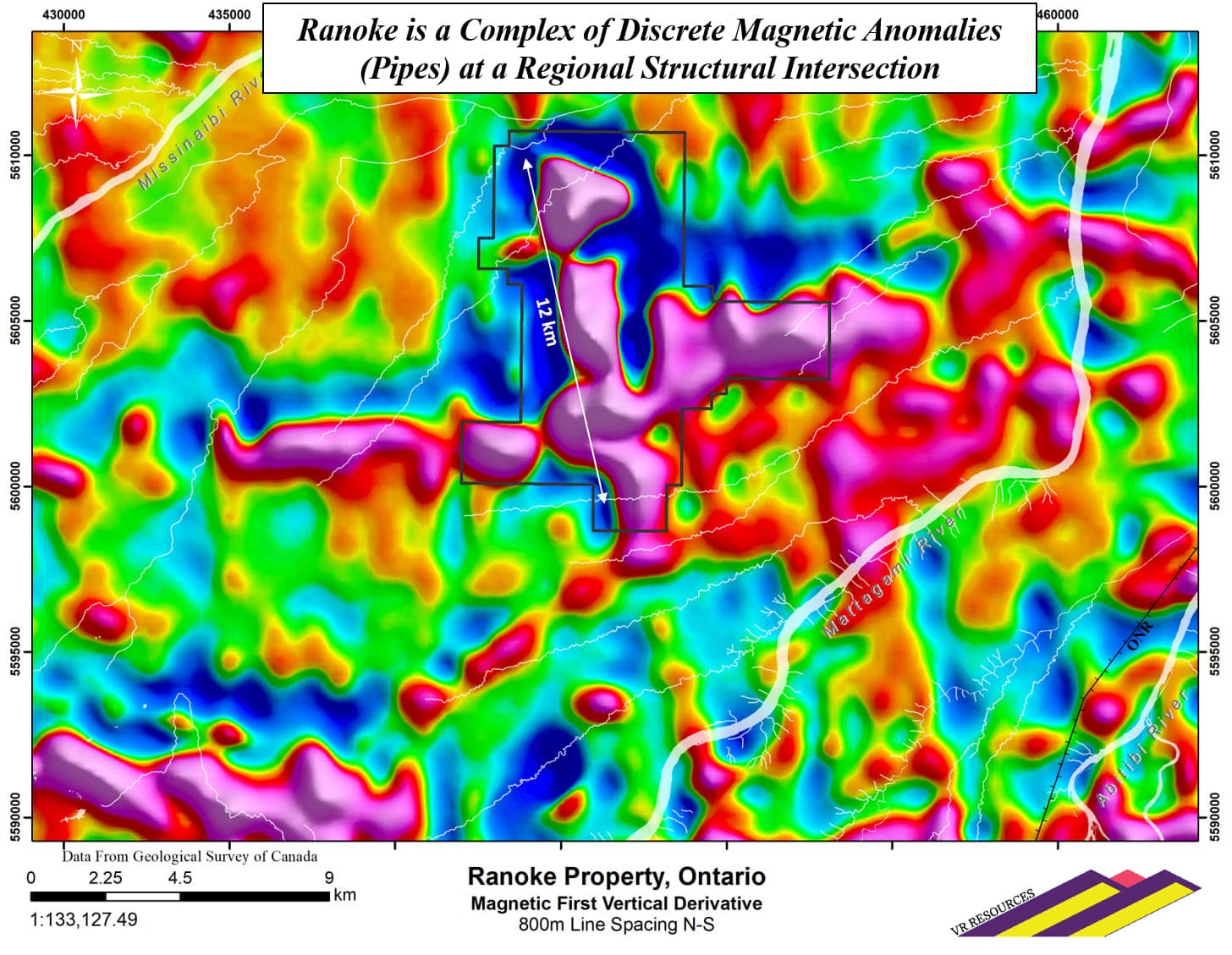
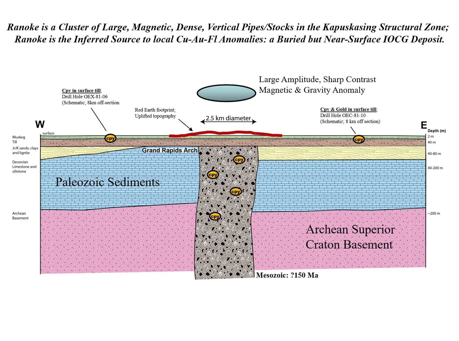
Ranoke is centered on a large and complex magnetic and co-spatial gravity anomaly that is targeted as an iron oxide copper-gold breccia pipe (IOCG) or carbonatite intrusion, and the source to local and regional copper-gold-fluorite heavy mineral anomalies. There is no outcrop in the region, and the near-surface target is under cover and not previously explored.
The magnetic anomaly is within the Kapuskasing Structural Zone (KSZ), a crustal-scale shear zone hundreds of kilometres long which bisects the Archean Superior province between James Bay and Lake Huron. The KSZ is well defined based on geophysical surveys and geologic mapping; it is a mega-structure with a long-lived history of repeated ultrabasic and alkaline intrusions spanning 1.6 billion years, and it is a prospective setting for a large IOCG hydrothermal system or carbonatite intrusion.
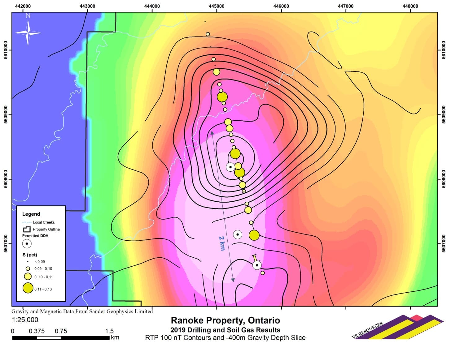
The Company completed three low-cost but high impact geophysical and geochemical surveys during the summer field season of 2019. The surveys were designed based on drill targets already apparent from the compilation of high-quality regional government surveys and archived mineral exploration assessment reports.
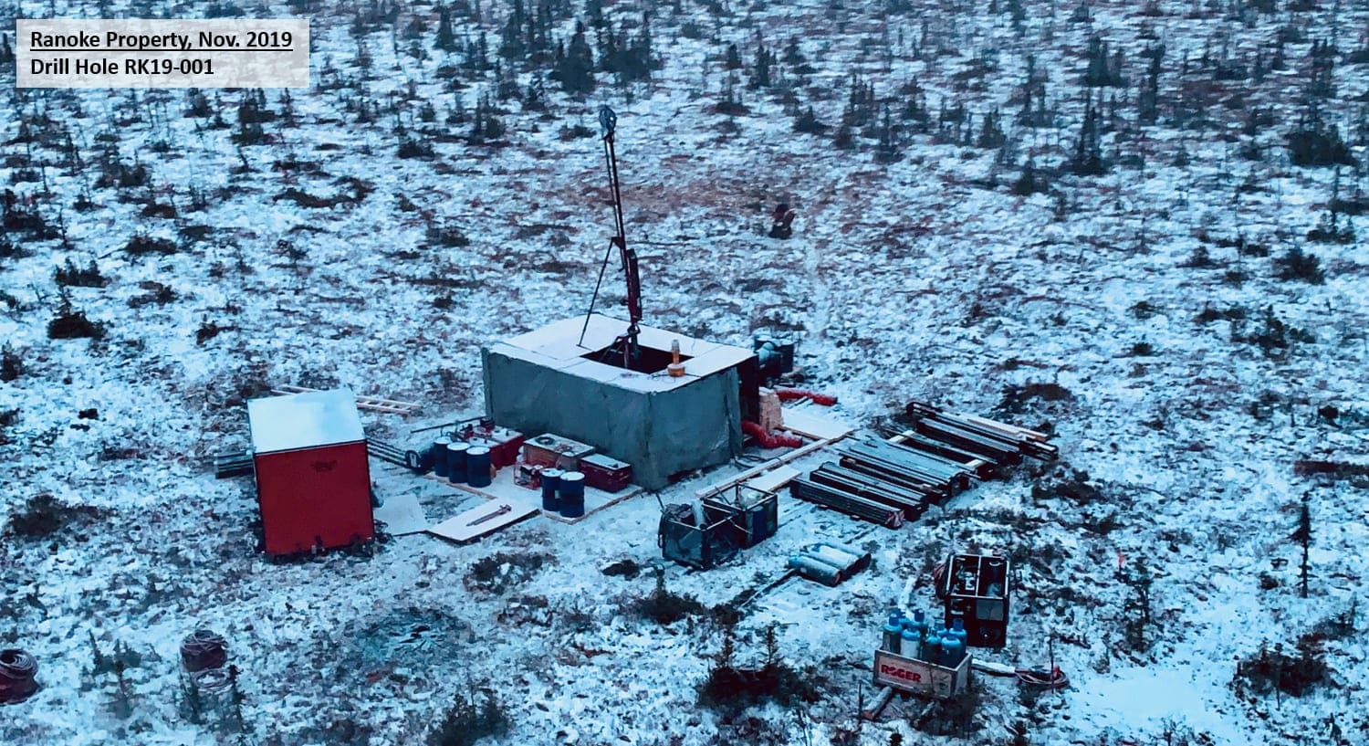
Upon completion of the gravity, magnetics, induced polarization and soil geochemistry surveys, the Company identified and prioritized a dozen locations for first-pass drilling, and successfully obtained a drill permit from the Ontario Ministry of Energy, Northern Development and Mines. A first pass drill program was executed in the winter season of 2020. Three holes were completed for a total of 1,516 metres, when the program was suspended due to lack of surface water and the escalation of the COVID-19 global pandemic. Results are positive towards an IOCG target, as described in the next section.
The schematic cross-section shown on this Project Page illustrates the target at Ranoke; a near-surface, large, vertical, magnetic, dense IOCG pipe or carbonatite intrusion. This cross-section is a representation of the discreet magnetic anomaly (pipe) at the northern end of the overall magnetic complex and structural intersection at Ranoke. This pipe is potentially the near-surface but till-covered source to copper and gold grains observed in the unconsolidated overburden in nearby reverse circulation drill holes completed in the early 1980’s during a reconnaissance evaluation of Cretaceous-aged coal seams in the Moose River Basin.
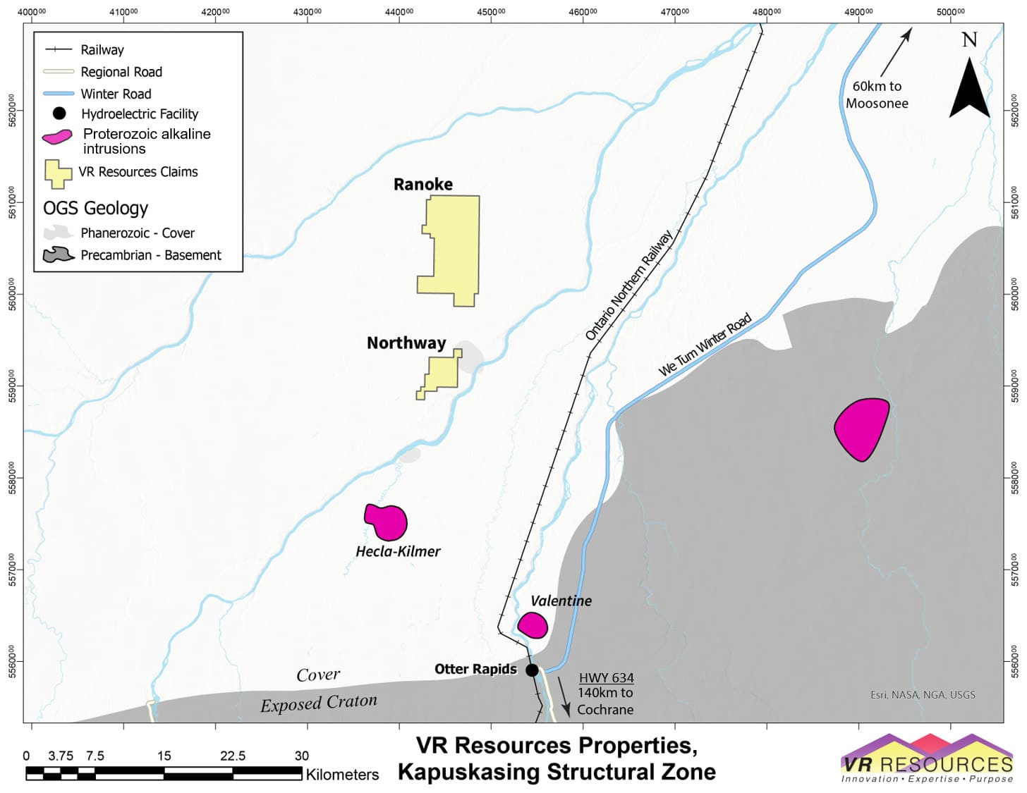
The Ranoke property is in the Moose River basin in northern Ontario, Canada. It is located between the Mattagami and Missinaibi rivers. The nearest town is Moosonee located on tide water some 100 kilometres to the northeast at James Bay. Kapuskasing is located about the same distance to the southwest, on the Trans-Canada Highway (Provincial HWY 11).
The property is 15 kilometers west of the active ONR railway spur line which connects the town of Moosonee with the mainline at Cochrane on the Trans Canada Highway, thus providing port access to the Moose River region.
Otter Rapids is an Ontario hydroelectric facility located on the Abitibi River about 50 kilometres to the southeast of the property. Provincial Highway 634 provides road access to Otter Rapids from Smooth Rock Falls, located at the junction of HWY 634 with the Trans-Canada Highway.
The Ranoke target is previously unexplored: it is under cover, it is north of exposed Archean Superior Province shield, and it is north of road access in northern Ontario. The specific area of the Ranoke property is not included in any mineral exploration assessment reports filed with the MENDM, and there are no historic drill holes located at Ranoke in the MENDM drill hole database.
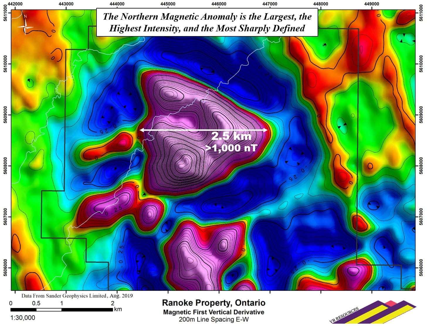
The Ranoke exploration target is a well defined, high intensity magnetic anomaly approximately 12 x 12 kilometres in size and evident on regional-scale Geological Survey of Canada (GSC) aeromagnetic maps. The anomaly delineates a regional-scale structural intersection, and individual magnetic anomalies are locally discordant to the regional magnetic grain evident in Archean basement rocks.
Work completed in 2019 – 2020 included:
- Airborne gravimeter and magnetic gradiometry survey over a 13 x 14 km area with 200 metre line spacing for 1,200 line-kilometres in total, including tie lines.
- Four soil gas geochemistry test lines across four different parts of the Ranoke magnetic complex, using a new soil gas technology that is best-suited for the hydrogeology and surficial geology of the Ranoke region. There were 128 stations in all, spaced 100 metres apart. Three different data streams were collected and analyzed: organic compounds, sulfur compounds and vapour phase multi-elements.
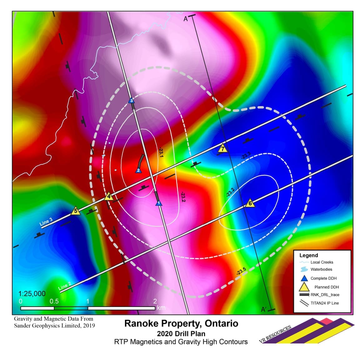
- Three geophysical test lines of ground-based induced-polarization (IP) using the TITAN 24 DCIP system were completed to test the main gravity anomaly for the presence of chargeable sulfide minerals.
The high-resolution airborne survey completed by VR in 2019 confirmed the location, geometry and intensity of the Ranoke complex evident on the historic GSC maps. The northern magnetic anomaly at Ranoke is both the largest, at > 2.3 km’s in diameter, and the highest intensity, at > 1,000 nT. It has a vertical, pipe-like geometry with sharply defined margins and a central apex which is consistent across TMI, RTP and 1VD magnetic products.
The 2019 airborne survey by VR also confirmed the discrete gravity anomaly evident at Ranoke in historic, regional gravity data collected by the Geological Survey of Canada. A singular, 2.5 mgal gravity anomaly is apparent in the 13 x 14 km survey completed by VR. It is co-spatial with the central part of the Ranoke magnetic complex overall, but it is locally discordant to the large, circular magnetic pipe at the north end of the complex.
The 2019 airborne survey by VR also confirmed the discrete gravity anomaly evident at Ranoke in historic, regional gravity data collected by the Geological Survey of Canada. A singular, 2.5 mgal gravity anomaly is apparent in the 13 x 14 km survey completed by VR. It is co-spatial with the central part of the Ranoke magnetic complex overall, but it is locally discordant to the large, circular magnetic pipe at the north end of the complex.
Drilling was designed to test a variety of different targets for a copper-gold hydrothermal iron oxide breccia body or a copper-gold – bearing carbonatite intrusion based on a variety of magnetic and IP chargeability attributes within the large and well defined, high intensity gravity anomaly in the northern part of the Ranoke magnetic complex.
Drilling began in November, 2019, resumed in January, 2020, and was suspended in March upon completion of three holes for a total of 1,516 metres because of the rapidly evolving COVID-19 global pandemic. The helicopter-assisted drilling is facilitated by a road-accessible camp located at the near-by Ontario Power Generation hydro-electric facility at Otter Rapids.
Results
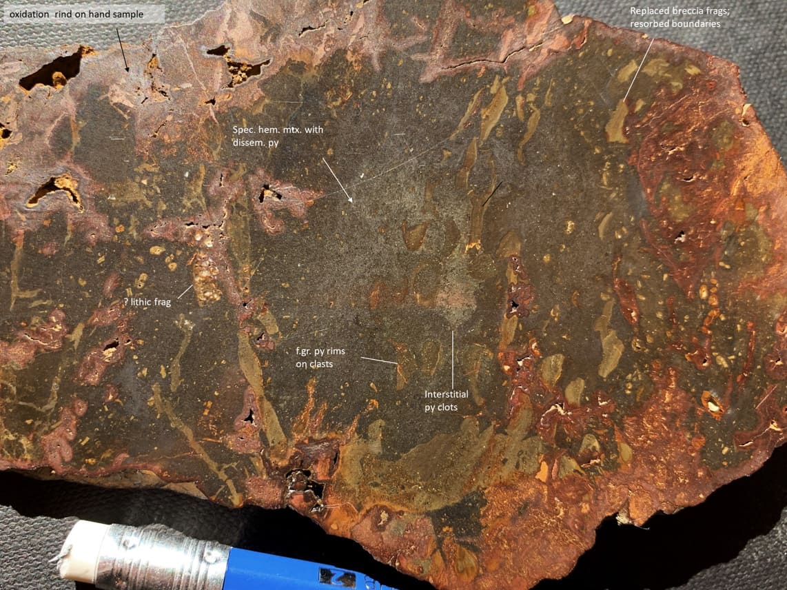
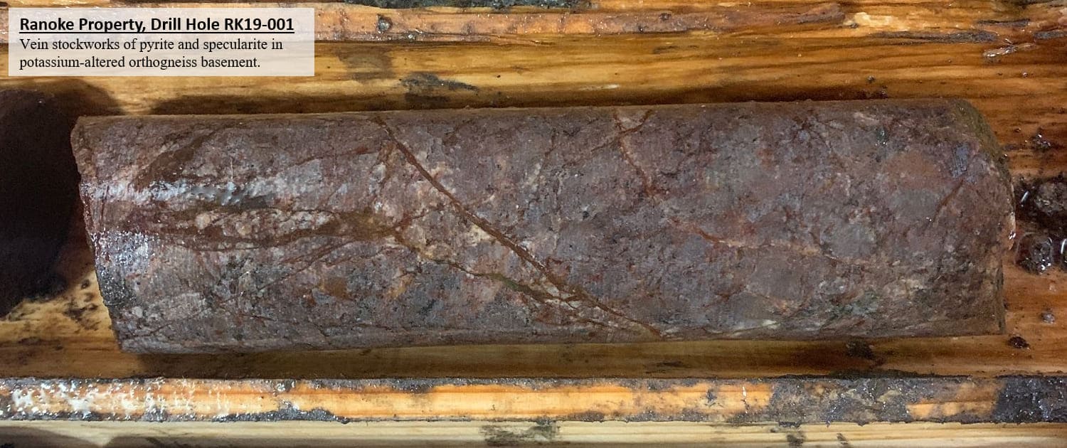
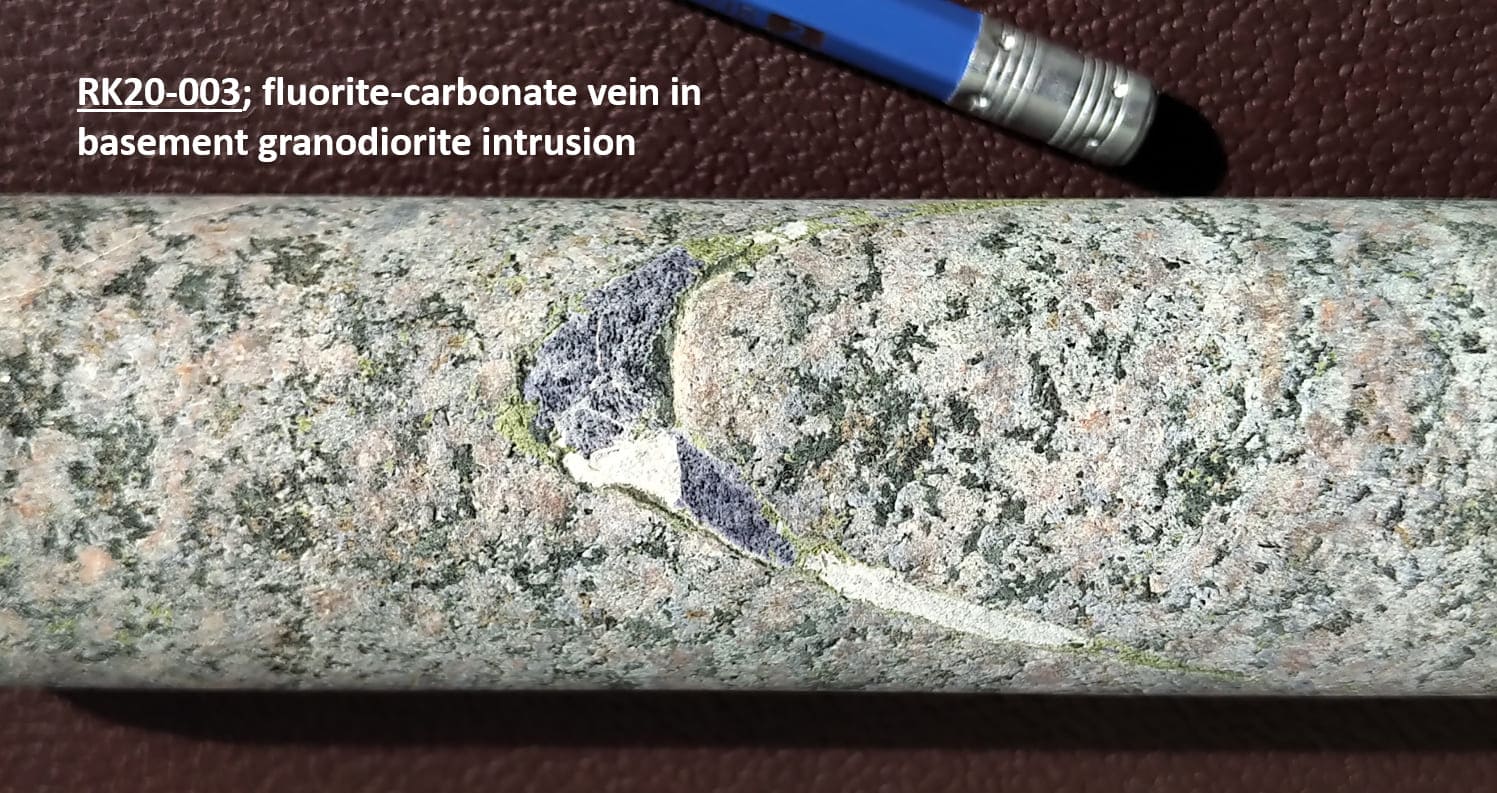
Hole 1 intersected veins of iron oxide and pyrite, and zones of iron carbonate breccia potentially sourced from hydrothermal fluids related to the main gravity anomaly which is targeted as a hydrothermal pipe of copper-gold iron oxide breccia pipe. Fluorite-carbonate veins were intersected in a basement intrusion in Hole 3. The fluorite is magmatically derived and hydrothermally precipitated. The fluorite veins in Hole 3 are significant because fluorite is a key attribute in both the IOCG and IOA exploration models for copper-gold breccias and REE-bearing carbonatite vein breccias, respectively, which are the targets in VR’s KSZ regional strategy.
Going Forward
The three drill now complete at Ranoke range from 500 - 650 metres in length. They constitute a north-south transect across the western part of the main gravity anomaly, and across the southern contact of the main magnetic anomaly.
Going forward, four additional holes forming an east-west transect across the Ranoke target will provide a complete first pass drill test of the target.